Villacarrillo | |
|---|---|
municipality | |
 Fair street in Villacarrillo | |
.svg.png.webp) Flag .svg.png.webp) Seal | |
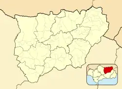 Villacarrillo Location in the Province of Jaén  Villacarrillo Villacarrillo (Andalusia)  Villacarrillo Villacarrillo (Spain) | |
| Coordinates: 38°06′N 3°05′W / 38.100°N 3.083°W | |
| Country | |
| Autonomous community | |
| Province | |
| Comarca | Las Villas |
| Area | |
| • Total | 239 km2 (92 sq mi) |
| Elevation | 812 m (2,664 ft) |
| Population (2018)[1] | |
| • Total | 10,795 |
| • Density | 45/km2 (120/sq mi) |
| Time zone | UTC+1 (CET) |
| • Summer (DST) | UTC+2 (CEST) |
Villacarrillo is a locality and Spanish municipality located in the south-western part of the region of Las Villas, in the province of Jaén. It borders the municipalities of Santisteban del Puerto, Iznatoraf, Villanueva del Arzobispo, Santiago-Pontones, Santo Tomé, Úbeda (by the enclave known as Rincón de Úbeda), and Sabiote.
The municipality includes the population centers of Villacarrillo - which hosts the capital of the Las Villas region -, Mogón, La Caleruela, Agrupación de Mogón y Arroturas. It has a population of 10,902 inhabitants.
References
- ↑ Municipal Register of Spain 2018. National Statistics Institute.
This article is issued from Wikipedia. The text is licensed under Creative Commons - Attribution - Sharealike. Additional terms may apply for the media files.