Arcola
Arcoa | |
|---|---|
| Comune di Arcola | |
 Arcola | |
Location of Arcola | |
 Arcola Location of Arcola in Italy  Arcola Arcola (Liguria) | |
| Coordinates: 44°7′N 9°54′E / 44.117°N 9.900°E | |
| Country | Italy |
| Region | Liguria |
| Province | La Spezia (SP) |
| Frazioni | Baccano, Battifollo, Cerri, Fresonara, Monti, Piano di Arcola, Ponte di Arcola, Ressora, Romito Magra, Termo-Pianazze e Trebiano |
| Area | |
| • Total | 16.4 km2 (6.3 sq mi) |
| Population (Dec. 2004)[2] | |
| • Total | 10,145 |
| • Density | 620/km2 (1,600/sq mi) |
| Demonym | Arcolani |
| Time zone | UTC+1 (CET) |
| • Summer (DST) | UTC+2 (CEST) |
| Postal code | 19021 |
| Dialing code | 0187 |
| Website | Official website |
Arcola (Ligurian: Arcoa[3]) is a commune in the Province of La Spezia, Liguria, Italy, located about 80 kilometres (50 mi) southeast of Genoa and about 7 kilometres (4 mi) northeast of La Spezia. As of 31 December 2004, it had a population of 10,145 and an area of 16.4 square kilometres (6.3 sq mi).[4]
The municipality of Arcola contains the frazioni (subdivisions, mainly villages and hamlets) Baccano, Termo, Fresonara, Monti, Romito Magra, Cerri, and Trebiano.
Arcola borders the following municipalities: La Spezia, Lerici, Sarzana, Vezzano Ligure.
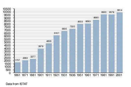
Demographic evolution
References
- ↑ "Superficie di Comuni Province e Regioni italiane al 9 ottobre 2011". Italian National Institute of Statistics. Retrieved 16 March 2019.
- ↑ "Popolazione Residente al 1° Gennaio 2018". Italian National Institute of Statistics. Retrieved 16 March 2019.
- ↑ Frisoni, Gaetano [in Italian] (1910). Dizionario Genovese-Italiano e Italiano-Genovese (in Italian). Genoa: Nuova Editrice Genovese.
- ↑ All demographics and other statistics: Italian statistical institute Istat.
External links
This article is issued from Wikipedia. The text is licensed under Creative Commons - Attribution - Sharealike. Additional terms may apply for the media files.