Börnicke | |
|---|---|
 Coat of arms | |
Location of Börnicke | |
 Börnicke  Börnicke | |
| Coordinates: 52°41′9″N 12°56′9″E / 52.68583°N 12.93583°E | |
| Country | Germany |
| State | Brandenburg |
| Town | Nauen |
| Area | |
| • Total | 19.07 km2 (7.36 sq mi) |
| Elevation | 34 m (112 ft) |
| Population (2017) | |
| • Total | 850 |
| • Density | 45/km2 (120/sq mi) |
| Time zone | UTC+01:00 (CET) |
| • Summer (DST) | UTC+02:00 (CEST) |
| Postal codes | 14641 |
| Dialling codes | 033230 |
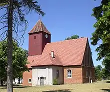
Evangelical-Lutheran chapel with steeple and clock in the village of Börnicke
Börnicke is a component locality (Ortsteil) of the town of Nauen in the Landkreis Havelland district of Brandenburg, Germany.
Neighbouring Cities
- Tietzow
- Staffelde
- Günefeld
- Kienberg
- Fehrbellin
Geography
Börnicke lies 34m above sea-level, 10 km north-east from the town Nauen. The town's area is around 19.07 km².
History
The town's name is from the Eastphalian for "small well".
This article is issued from Wikipedia. The text is licensed under Creative Commons - Attribution - Sharealike. Additional terms may apply for the media files.