Sunray | |
|---|---|
 Sunray Location within the state of Oklahoma  Sunray Sunray (the United States) | |
| Coordinates: 34°24′40″N 97°57′37″W / 34.41111°N 97.96028°W | |
| Country | United States |
| State | Oklahoma |
| County | Stephens |
| Area | |
| • Total | 1.78 sq mi (4.62 km2) |
| • Land | 1.75 sq mi (4.53 km2) |
| • Water | 0.04 sq mi (0.09 km2) |
| Elevation | 1,073 ft (327 m) |
| Population (2020) | |
| • Total | 853 |
| • Density | 487.99/sq mi (188.46/km2) |
| Time zone | UTC-6 (Central (CST)) |
| • Summer (DST) | UTC-5 (CDT) |
| FIPS code | 40-71650 |
| GNIS feature ID | 2812871[2] |
Sunray (also Beckett) is a small unincorporated community in Stephens County, Oklahoma, United States. It is south of Duncan on U.S. Route 81.
The community is adjacent to the old DX-Sunray refinery (TOSCO Corp. Duncan refinery) which closed in 1983 and was imploded in 2006.
Demographics
| Census | Pop. | Note | %± |
|---|---|---|---|
| 2020 | 853 | — | |
| U.S. Decennial Census[3] | |||
Climate
Climate is characterized by relatively high temperatures and evenly distributed precipitation throughout the year. The Köppen Climate Classification subtype for this climate is "Cfa" (Humid Subtropical Climate).[4]
References
- ↑ "ArcGIS REST Services Directory". United States Census Bureau. Retrieved September 20, 2022.
- 1 2 U.S. Geological Survey Geographic Names Information System: Sunray, Oklahoma
- ↑ "Census of Population and Housing". Census.gov. Retrieved June 4, 2016.
- ↑ "Sunray, Oklahoma Köppen Climate Classification (Weatherbase)". Weatherbase.
Municipalities and communities of Stephens County, Oklahoma, United States | ||
|---|---|---|
| Cities | 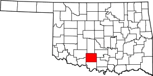 Stephens County map | |
| Towns | ||
| CDP | ||
| Other communities | ||
| Ghost town | ||
| Indian reservation | ||
| Footnotes | ‡This populated place also has portions in an adjacent county or counties | |
This article is issued from Wikipedia. The text is licensed under Creative Commons - Attribution - Sharealike. Additional terms may apply for the media files.