Belobaka | |
|---|---|
 Belobaka Location in Madagascar | |
| Coordinates: 18°59′S 45°41′E / 18.983°S 45.683°E | |
| Country | |
| Region | Bongolava |
| District | Tsiroanomandidy |
| Elevation | 806 m (2,644 ft) |
| Population (2001)[2] | |
| • Total | 18,000 |
| Time zone | UTC3 (EAT) |
| Postal code | 119 |
Belobaka is a rural municipality Madagascar. It belongs to the district of Tsiroanomandidy, which is a part of Bongolava Region. The population of the commune was estimated to be approximately 18,000 in 2001 commune census.[2]
Primary and junior level secondary education are available in town. The majority 90% of the population of the commune are farmers. The most important crop is rice, while other important products are maize and cassava. Services provide employment for 10% of the population.[2]
Rivers
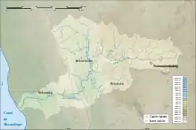
situation map of Belobaka
Belobaka lies at the Ifondry River
References
- ↑ Estimated based on DEM data from Shuttle Radar Topography Mission
- 1 2 3 "ILO census data". Cornell University. 2002. Retrieved 2008-05-02.
Capital: Tsiroanomandidy | ||
| Fenoarivobe (8) - 115 | 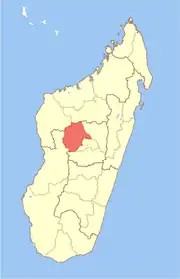 | |
| Tsiroanomandidy (16) - 119 | ||
2 districts; 25 communes | ||
18°59′S 45°41′E / 18.983°S 45.683°E
This article is issued from Wikipedia. The text is licensed under Creative Commons - Attribution - Sharealike. Additional terms may apply for the media files.