| Biltine Prefecture إقليم بلتن | |||||||||
|---|---|---|---|---|---|---|---|---|---|
| Prefecture of Chad | |||||||||
| 1960–1999 | |||||||||
 | |||||||||
 | |||||||||
| Capital | Biltine | ||||||||
| Area | |||||||||
| • Coordinates | 14°31′N 20°55′E / 14.517°N 20.917°E | ||||||||
• 1960 | 55,000 km2 (21,000 sq mi) | ||||||||
• 1993 | 46,850 km2 (18,090 sq mi) | ||||||||
| Population | |||||||||
• 1960 | 141686 | ||||||||
• 1993 | 187807 | ||||||||
| • Type | Prefecture | ||||||||
| Historical era | Cold War | ||||||||
• Established[1] | 1960 | ||||||||
• Disestablished[1] | 1 September 1999 | ||||||||
| Political subdivisions | Sub-prefectures (1993)[2]
| ||||||||
| |||||||||
| Area and population source:[1] | |||||||||
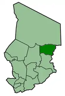
Biltine Prefecture (Arabic: ﺇﻗﻠﻴﻢ بلتن) was one of the 14 prefectures of Chad. Located in the east of the country, Biltine covered an area of 46,850 square kilometers and had a population of 184,807 in 1993. Its capital was Biltine. The Amdang language, spoken in parts of the prefecture, is sometimes called "Biltine".
References
- 1 2 3 "Administrative Divisions of Countries: Regions of Chad". www.statoids.com.
- ↑ "Administrative Divisions of Countries: Departments of Chad". www.statoids.com.
| |||
|
Batha · Biltine · Borkou-Ennedi-Tibesti · Chari-Baguirmi · Guéra · Kanem · Lac · Logone Occidental · Logone Oriental · Mayo-Kébbi · Moyen-Chari · Ouaddaï · Salamat · Tandjilé · | |||
|
See also : Regions of Chad - Departments of Chad |
This article is issued from Wikipedia. The text is licensed under Creative Commons - Attribution - Sharealike. Additional terms may apply for the media files.