| Carn an Fhidhleir | |
|---|---|
 Carn an Fhidhleir | |
| Highest point | |
| Elevation | 994 m (3,261 ft)[1] |
| Prominence | 286 m (938 ft) |
| Listing | Munro, Marilyn |
| Coordinates | 56°56′09″N 3°48′06″W / 56.9359°N 3.8017°W |
| Geography | |
| Location | Highland / Perth and Kinross / Aberdeenshire, Scotland |
| Parent range | Grampian Mountains |
| OS grid | NN904841 |
| Topo map | OS Landranger 43 |
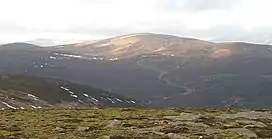
Carn an Fhidhleir (994 m) is a mountain in the Grampian Mountains of Scotland. It lies on the border of Inverness-shire, Perthshire and Aberdeenshire, in one of the most remote areas of Scotland between the Cairngorms and the Mounth.
A domed mountain, it lies at the heart of a vast roadless area. It is possible to reach the peak from Glen Tilt or via the Linn of Dee by mountain bike.[2]
References
- ↑ "Carn an Fhidhleir". hill-bagging.co.uk. Retrieved 18 May 2019.
- ↑ "walkhighlands Carn an Fhidhleir". walkhighlands.co.uk. Retrieved 18 May 2019.
This article is issued from Wikipedia. The text is licensed under Creative Commons - Attribution - Sharealike. Additional terms may apply for the media files.