Serra Riccò
A Særa | |
|---|---|
| Comune di Serra Riccò | |
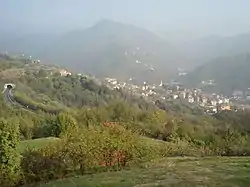 View of the municipal territory. | |
 Coat of arms | |
Location of Serra Riccò | |
 Serra Riccò Location of Serra Riccò in Italy  Serra Riccò Serra Riccò (Liguria) | |
| Coordinates: 44°30′N 8°56′E / 44.500°N 8.933°E | |
| Country | Italy |
| Region | Liguria |
| Metropolitan city | Genoa (GE) |
| Frazioni | Castagna, Orero, Prelo, Mainetto, Pedemonte (municipal seat), San Cipriano, Serra, Valleregia |
| Government | |
| • Mayor | Angela Negri |
| Area | |
| • Total | 26.20 km2 (10.12 sq mi) |
| Elevation | 187 m (614 ft) |
| Population (1 January 2021)[2] | |
| • Total | 7,685 |
| • Density | 290/km2 (760/sq mi) |
| Demonym | Serrariccoesi |
| Time zone | UTC+1 (CET) |
| • Summer (DST) | UTC+2 (CEST) |
| Postal code | 16010 |
| Dialing code | 010 |
| Patron saint | Saint Roch (San Rocco) |
| Saint day | 16 August |
| Website | Official website |
Serra Riccò (Ligurian: A Særa) is a comune (municipality) in the Metropolitan City of Genoa, in the Italian region Liguria, located about 9 kilometres (6 mi) north of Genoa, in the Val Polcevera.
Serra Riccò borders the following municipalities: Casella, Genoa, Mignanego, Montoggio, Sant'Olcese, Savignone. It is composed by a series of villages, the municipal seat being located in Pedemonte.
References
- ↑ "Superficie di Comuni Province e Regioni italiane al 9 ottobre 2011". Italian National Institute of Statistics. Retrieved 16 March 2019.
- ↑ All demographics and other statistics: Italian statistical institute Istat.
External links
This article is issued from Wikipedia. The text is licensed under Creative Commons - Attribution - Sharealike. Additional terms may apply for the media files.