Chawang
ฉวาง | |
|---|---|
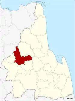 District location in Nakhon Si Thammarat province | |
| Coordinates: 8°25′34″N 99°30′17″E / 8.42611°N 99.50472°E | |
| Country | Thailand |
| Province | Nakhon Si Thammarat |
| Seat | Chawang |
| Area | |
| • Total | 528.2 km2 (203.9 sq mi) |
| Population (2005) | |
| • Total | 65,787 |
| • Density | 124.5/km2 (322/sq mi) |
| Time zone | UTC+7 (ICT) |
| Postal code | 80150 |
| Geocode | 8004 |
Chawang (Thai: ฉวาง, pronounced [t͡ɕʰā.wǎːŋ]) is a district (amphoe) of Nakhon Si Thammarat province, southern Thailand.
Geography
Neighboring districts are (from the northeast clockwise): Phipun, Lan Saka, Chang Klang, Na Bon, Thung Yai, and Tham Phannara of Nakhon Si Thammarat; Wiang Sa of Surat Thani province.
The east of the district is part of the Khao Luang National Park.
Climate
| Climate data for Chawang (1981–2010) | |||||||||||||
|---|---|---|---|---|---|---|---|---|---|---|---|---|---|
| Month | Jan | Feb | Mar | Apr | May | Jun | Jul | Aug | Sep | Oct | Nov | Dec | Year |
| Record high °C (°F) | 37.5 (99.5) |
39.5 (103.1) |
39.1 (102.4) |
41.0 (105.8) |
39.5 (103.1) |
38.2 (100.8) |
36.2 (97.2) |
36.2 (97.2) |
35.4 (95.7) |
36.2 (97.2) |
38.3 (100.9) |
35.5 (95.9) |
41.0 (105.8) |
| Mean daily maximum °C (°F) | 32.8 (91.0) |
34.6 (94.3) |
35.3 (95.5) |
35.5 (95.9) |
33.8 (92.8) |
32.9 (91.2) |
32.6 (90.7) |
32.6 (90.7) |
32.5 (90.5) |
31.8 (89.2) |
31.4 (88.5) |
31.5 (88.7) |
33.1 (91.6) |
| Daily mean °C (°F) | 26.2 (79.2) |
27.2 (81.0) |
27.9 (82.2) |
28.3 (82.9) |
27.6 (81.7) |
27.3 (81.1) |
26.9 (80.4) |
27.1 (80.8) |
26.9 (80.4) |
26.4 (79.5) |
26.3 (79.3) |
25.9 (78.6) |
27.0 (80.6) |
| Mean daily minimum °C (°F) | 20.7 (69.3) |
20.3 (68.5) |
21.2 (70.2) |
22.1 (71.8) |
22.8 (73.0) |
22.7 (72.9) |
22.5 (72.5) |
22.5 (72.5) |
22.6 (72.7) |
22.7 (72.9) |
22.4 (72.3) |
21.5 (70.7) |
22.0 (71.6) |
| Record low °C (°F) | 15.0 (59.0) |
16.2 (61.2) |
16.2 (61.2) |
17.7 (63.9) |
17.5 (63.5) |
19.5 (67.1) |
19.2 (66.6) |
19.0 (66.2) |
19.5 (67.1) |
16.8 (62.2) |
17.7 (63.9) |
16.5 (61.7) |
15.0 (59.0) |
| Average rainfall mm (inches) | 38.4 (1.51) |
39.0 (1.54) |
116.9 (4.60) |
105.4 (4.15) |
206.2 (8.12) |
187.8 (7.39) |
192.1 (7.56) |
220.0 (8.66) |
243.0 (9.57) |
221.6 (8.72) |
203.9 (8.03) |
120.6 (4.75) |
1,894.9 (74.60) |
| Average rainy days | 7.6 | 3.9 | 9.9 | 12.2 | 18.2 | 17.8 | 19.3 | 20.0 | 20.8 | 24.0 | 17.5 | 12.5 | 183.7 |
| Average relative humidity (%) | 80 | 75 | 76 | 79 | 84 | 85 | 86 | 85 | 86 | 87 | 87 | 84 | 83 |
| Mean monthly sunshine hours | 198.4 | 180.8 | 201.5 | 183.0 | 155.0 | 150.0 | 114.7 | 151.9 | 144.0 | 108.5 | 138.0 | 142.6 | 1,868.4 |
| Mean daily sunshine hours | 6.4 | 6.4 | 6.5 | 6.1 | 5.0 | 5.0 | 3.7 | 4.9 | 4.8 | 3.5 | 4.6 | 4.6 | 5.1 |
| Source 1: Thai Meteorological Department[1] | |||||||||||||
| Source 2: Office of Water Management and Hydrology, Royal Irrigation Department (sun and humidity)[2] | |||||||||||||
Administration
The district is divided into 10 sub-districts (tambons), which are further subdivided into 84 villages (mubans). There are three subdistrict municipalities (thesaban tambons): Chan Di covers tambon Chan Di, and Chawang and Mai Riang each cover parts of the same-named tambons. There are a further 10 tambon administrative organizations (TAO).
|
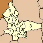 |
Missing numbers are now part of Tham Phannara and Chang Klang Districts.
References
- ↑ "Climatological Data for the Period 1981–2010". Thai Meteorological Department. p. 24. Retrieved 8 August 2016.
- ↑ "ปริมาณการใช้น้ำของพืชอ้างอิงโดยวิธีของ Penman Monteith (Reference Crop Evapotranspiration by Penman Monteith)" (PDF) (in Thai). Office of Water Management and Hydrology, Royal Irrigation Department. p. 113. Retrieved 8 August 2016.