| Churún River | |
|---|---|
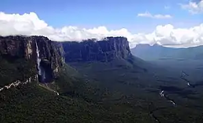 Churún River devil's canyon and Angel Falls. | |
| Location | |
| Country | Venezuela |
| State | Bolívar (state) |
| Physical characteristics | |
| Source | |
| • location | Auyán-tepui |
| • elevation | 8,040 ft (2,450 m) |
| Mouth | Carrao River |
| Length | 66 km (41 mi) |
| Basin size | 580 km2 (220 sq mi) |
| Discharge | |
| • average | 20,000 cu ft/s (570 m3/s) |
The Churún River (Spanish: Río Churún) is a river in Venezuela, part of the Orinoco River basin. It is located around 6°04′00″N 62°36′00″W / 6.0666667°N 62.6°W, in Canaima National Park and a tributary comes from the Angel Falls, which are the world's tallest single-drop waterfall. It rises in Canaima National Park, and its mouth is the Carrao River.[1]
Gallery
.jpg.webp) Rio Churun is the gateway to Angel Falls.
Rio Churun is the gateway to Angel Falls.
References
This article is issued from Wikipedia. The text is licensed under Creative Commons - Attribution - Sharealike. Additional terms may apply for the media files.