Copacabana | |
|---|---|
Municipality and town | |
 | |
 Flag .svg.png.webp) Seal | |
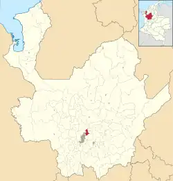 Location of the municipality and town of Copacabana, Antioquia in the Antioquia Department of Colombia | |
 Copacabana Location in Colombia | |
| Coordinates: 6°20′N 75°30′W / 6.333°N 75.500°W | |
| Country | |
| Department | |
| Founded | 1615 |
| Government | |
| • Mayor | Augusto Hector Monsalve |
| Area | |
| • Municipality and town | 67.76 km2 (26.16 sq mi) |
| • Urban | 7.62 km2 (2.94 sq mi) |
| Elevation | 1,454 m (4,770 ft) |
| Population (2018 census)[1] | |
| • Municipality and town | 77,884 |
| • Density | 1,100/km2 (3,000/sq mi) |
| • Urban | 62,343 |
| • Urban density | 8,200/km2 (21,000/sq mi) |
| Demonym | Copacabanese |
| Time zone | UTC-5 (Colombia Standard Time) |
| Area code | 57 + 4 |
| Website | Official website (in Spanish) |
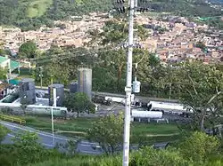
Copacabana is a town and municipality in the Colombian department of Antioquia. Founded in 1615, Copacabana is part of the Metropolitan Area of the Aburrá Valley.
References
- ↑ Citypopulation.de Population of Copacabana municipality with localities
This article is issued from Wikipedia. The text is licensed under Creative Commons - Attribution - Sharealike. Additional terms may apply for the media files.