| Étang de Leucate Étang de Salses | |
|---|---|
 | |
 Étang de Leucate Étang de Salses | |
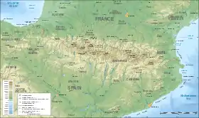
| Location | Pyrénées-Orientales and Aude |
| Coordinates | 42°50′52″N 2°59′47″E / 42.847678°N 2.996349°E |
| Type | lagoon |
| Basin countries | France |
| Surface area | 54 km2 (21 sq mi) |
| Average depth | 1.8 m (5 ft 11 in) |
| Surface elevation | 0 m (0 ft) |
| Official name | Étang de Salses-Leucate |
| Designated | 30 June 2017 |
| Reference no. | 2307[1] |
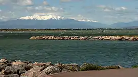
Étang de Leucate or Étang de Salses is a lake in Pyrénées-Orientales and Aude, France. At an elevation of 0 m, its surface area is 54 km2. It has been designated as a protected Ramsar site since 2017.[1] It is separated from the Mediterranean Sea by a narrow strip of land, occupied by the villages of Leucate and Le Barcarès.
 View from East
 View from West
See also
References
- 1 2 "Étang de Salses-Leucate". Ramsar Sites Information Service. Retrieved 25 May 2020.
This article is issued from Wikipedia. The text is licensed under Creative Commons - Attribution - Sharealike. Additional terms may apply for the media files.