.svg.png.webp) | ||||
|---|---|---|---|---|
| Friendship Circumferential Road | ||||
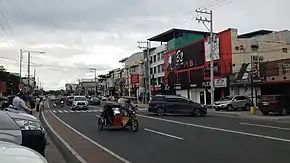
 The Fil-Am Friendship Highway in the Koreatown area of Angeles City | ||||
| Route information | ||||
| Maintained by the Department of Public Works and Highways – Pampanga 1st District Engineering Office and Pampanga 3rd District Engineering Office | ||||
| Component highways | ||||
| Major junctions | ||||
| North end | Don Juico Avenue in Angeles City | |||
| ||||
| South end | ||||
| Location | ||||
| Country | Philippines | |||
| Provinces | Pampanga | |||
| Major cities | Angeles City and San Fernando | |||
| Highway system | ||||
| ||||
| ||||
The Filipino–American Friendship Highway, officially the Friendship Circumferential Road (or simply the Friendship Highway), is a secondary national road traversing the cities of Angeles City and San Fernando in Pampanga, Philippines.[1][2]
The entire highway is designated as National Route 216 (N216) of the Philippine highway network.
External links
 Media related to Filipino–American Friendship Highway at Wikimedia Commons
References
- ↑ "Pampanga 1st". www.dpwh.gov.ph. Retrieved 2018-09-09.
- ↑ "Pampanga 3rd". www.dpwh.gov.ph. Retrieved 2018-09-09.
This article is issued from Wikipedia. The text is licensed under Creative Commons - Attribution - Sharealike. Additional terms may apply for the media files.