Fljótsdalshérað | |
|---|---|
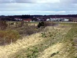 Skyline of Fljótsdalshérað | |
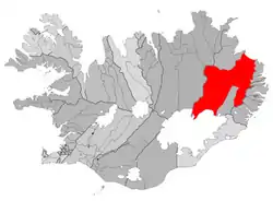 Location of the municipality | |
 Fljótsdalshérað | |
| Coordinates: 65°15′50″N 14°23′42″W / 65.264°N 14.395°W | |
| Country | Iceland |
| Region | Eastern Region |
| Constituency | Northeast Constituency |
| Municipality | Múlaþing |
| Government | |
| • Mayor | Björn Ingimarsson |
| Area | |
| • Total | 8,884 km2 (3,430 sq mi) |
| Population (2018) | |
| • Total | 3,580 |
| • Density | 0.40/km2 (1.0/sq mi) |
| Postal code(s) | 700, 701 |
| Website | egilsstadir |
Fljótsdalshérað (Icelandic pronunciation: [ˈfljoutsˌtalsˌçɛːraθ] ⓘ) was a municipality located in eastern Iceland. In 2020 it merged with three neighbouring municipalities to form Múlaþing.
References
This article is issued from Wikipedia. The text is licensed under Creative Commons - Attribution - Sharealike. Additional terms may apply for the media files.