Geversdorf | |
|---|---|
 Coat of arms | |
Location of Geversdorf | |
 Geversdorf  Geversdorf | |
| Coordinates: 53°48′N 09°05′E / 53.800°N 9.083°E | |
| Country | Germany |
| State | Lower Saxony |
| District | Cuxhaven |
| Municipality | Cadenberge |
| Area | |
| • Total | 21.62 km2 (8.35 sq mi) |
| Highest elevation | 5 m (16 ft) |
| Lowest elevation | 0 m (0 ft) |
| Population (2015-12-31) | |
| • Total | 726 |
| • Density | 34/km2 (87/sq mi) |
| Time zone | UTC+01:00 (CET) |
| • Summer (DST) | UTC+02:00 (CEST) |
| Postal codes | 21784 |
| Dialling codes | 04752, 04753 and 04772 |
| Vehicle registration | CUX |
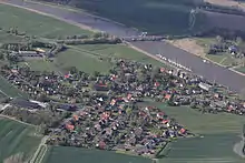
Geversdorf
Geversdorf is a village and a former municipality in the district of Cuxhaven, in Lower Saxony, Germany. Since 1 November 2016, it is part of the municipality Cadenberge.
Geversdorf belonged to the Prince-Archbishopric of Bremen, established in 1180. In 1648 the Prince-Archbishopric was transformed into the Duchy of Bremen, which was first ruled in personal union by the Swedish Crown – interrupted by a Danish occupation (1712-1715) – and from 1715 on by the Hanoverian Crown. The Kingdom of Hanover incorporated the Duchy in a real union and the Ducal territory became part of the new Stade Region, established in 1823.
References
This article is issued from Wikipedia. The text is licensed under Creative Commons - Attribution - Sharealike. Additional terms may apply for the media files.