| Gurghiu Görgény, Rosengraben | |
|---|---|
 | |
 | |
| Location | |
| Country | Romania |
| Counties | Mureș County |
| Municipalities | Ibăneşti, Gurghiu, Reghin |
| Physical characteristics | |
| Source | Gurghiu Mountains |
| • elevation | 1,200 m (3,900 ft) |
| Mouth | Mureș |
• location | Reghin |
• coordinates | 46°47′34″N 24°43′26″E / 46.7928°N 24.7239°E |
| Length | 53 km (33 mi) |
| Basin size | 563 km2 (217 sq mi) |
| Basin features | |
| Progression | Mureș→ Tisza→ Danube→ Black Sea |
| Tributaries | |
| • left | Secuș, Orșova |
| • right | Fâncel, Isticeu, Cașva |
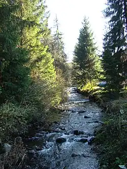
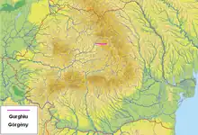
The Gurghiu (Hungarian: Görgény-patak, German: Rosengraben) is a river in the Gurghiu Mountains, Mureș County, northern Romania. It is a left tributary of the river Mureș.[1][2] It flows through the municipalities Ibăneşti, Hodac, Gurghiu and Solovăstru, and joins the Mureș in the town Reghin.[3] Its length is 53 km (33 mi) and its basin size is 563 km2 (217 sq mi).[2]
Tributaries
The following rivers are tributaries to the river Gurghiu (from source to mouth):[2]
References
- ↑ "Planul național de management. Sinteza planurilor de management la nivel de bazine/spații hidrografice, anexa 7.1" (PDF, 5.1 MB). Administrația Națională Apele Române. 2010. pp. 274–275.
- 1 2 3 Atlasul cadastrului apelor din România. Partea 1 (in Romanian). Bucharest: Ministerul Mediului. 1992. pp. 139–140. OCLC 895459847. River code: IV.1.54
- ↑ Gurghiu / Creanga Alba (jud. Mures), e-calauza.ro
This article is issued from Wikipedia. The text is licensed under Creative Commons - Attribution - Sharealike. Additional terms may apply for the media files.