Ham | |
|---|---|
_(21825)_3-08-2020_13-28-42.jpg.webp) | |
 Flag  Coat of arms | |
Location of Ham | |
 Ham Location in Belgium
Location of Ham in Limburg 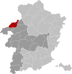 | |
| Coordinates: 51°06′N 05°08′E / 51.100°N 5.133°E | |
| Country | |
| Community | Flemish Community |
| Region | Flemish Region |
| Province | Limburg |
| Arrondissement | Hasselt |
| Government | |
| • Mayor | Marc Heselmans (CD&V) |
| • Governing party/ies | CD&V, Open VLD |
| Area | |
| • Total | 32.79 km2 (12.66 sq mi) |
| Population (2018-01-01)[1] | |
| • Total | 10,824 |
| • Density | 330/km2 (850/sq mi) |
| Postal codes | 3945 |
| NIS code | 71069 |
| Area codes | 013 - 011 |
| Website | www.ham.be |
Ham (Dutch pronunciation: [ˈɦɑm] ⓘ) is a municipality located in the Belgian province of Limburg. On January 1, 2006, Ham had a total population of 9,705. The total area is 32.69 km2 (13 sq mi) which gives a population density of 297 inhabitants per km² (746/sq mi).
Demographics
| Year | Population | Male population | Female population | Density |
|---|---|---|---|---|
| 2002 | 9,387 | 4,703 | 4,684 | 284.71/km² (722/sq mi) |
In August, 2008 the population of Ham exceeded 10,000 inhabitants.
Fusion
The municipality of Ham was created January 1977 by the fusion of the municipalities of Oostham and Kwaadmechelen.
References
- ↑ "Wettelijke Bevolking per gemeente op 1 januari 2018". Statbel. Retrieved 9 March 2019.
External links
 Media related to Ham, Belgium at Wikimedia Commons
- Official website - Only available in Dutch
Places adjacent to Ham, Belgium | ||||||||||||||||
|---|---|---|---|---|---|---|---|---|---|---|---|---|---|---|---|---|
| ||||||||||||||||
| Hasselt | 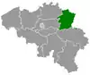 | |
|---|---|---|
| Maaseik | ||
| Tongeren | ||
| ||
This article is issued from Wikipedia. The text is licensed under Creative Commons - Attribution - Sharealike. Additional terms may apply for the media files.