Gulshan District
ضلع کراچی شرقی | |
|---|---|
District | |
| Karachi East | |
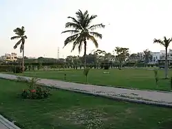 | |
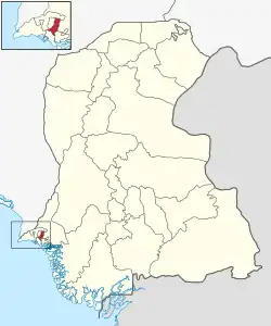 Map of Gulshan District (Karachi East) | |
| Country |  Pakistan Pakistan |
| Province |  Sindh Sindh |
| Division | Karachi |
| Established | 1972 |
| Re-established | 11 July 2011 |
| Headquarters[1] | DC East office |
| Towns | 5[2][3]
|
| Government | |
| • Deputy Commissioner | Altaf Sheikh[4] |
| Area | |
| • Total | 139 km2 (54 sq mi) |
| Population | |
| • Total | 3,950,031 |
| • Density | 28,000/km2 (74,000/sq mi) |
| Website | www |
Gulshan District (formerly Karachi East) (Urdu: ضلع کراچی مشرقی ) is an administrative district of Karachi Division in Sindh, Pakistan.
History
The district was established in 1972.
The district was abolished in 2000, and was divided into four towns namely:
On 11 July 2015, the Sindh Government restored again Karachi East District.[6]
In November 2013, three eastern towns of Karachi East District separated to form a new District named Korangi also Jamshed Town of Karachi South District was added into this district. Now Karachi East comprises two towns: Jamshed and Gulshan.[7][8][9]
In 2022, it was divided into five towns namely Sohrab Goth Town, Safoora Town, Gulshan Town, Jinnah Town and Chanesar Town with 43 union councils and 172 wards respectively.[10]
Demographics
At the time of the 2017 census, Gulshan district had 498,183 households and a population of 2,875,315. Gulshan had a sex ratio of 908 females per 1000 males and a literacy rate of 76.00%: 78.26% for males and 73.49% for females. 657,102 (22.85%) were under 10 years of age.[11] In 2023, the district had 665,452 households and a population of 3,950,031.[5]
The majority religion is Islam, with 95.31% of the population. Christianity is practiced by 3.14% and Hinduism (including Scheduled Castes) is practiced by 1.38% of the population.
At the time of the 2017 census, 37.51% of the population spoke Urdu, 13.91% Pashto, 13.29% Punjabi, 11.55% Sindhi, 8.38% Saraiki, 3.29% Hindko and 2.34% Balochi as their first language.[11]
Administrative Towns in Karachi East
Following is the list of administrative towns of Karachi East District.[12]
| Union Council |
|---|
| U.C. 1 Pakistan Quarters |
| U.C. 2 Soldier Bazar |
| U.C. 3 Patel Para |
| U.C. 4 Jamshed Quarters |
| U.C. 5 Martin Quarters |
| U.C. 6 Jamshed Quarters |
| U.C. 7 Bahadurabad |
| U.C. 8 Delhi Mercantile |
| U.C. 9 Tunisia Line |
| U.C. 10 Jacob Lines |
| U.C. 11 Behind Jacob Lines |
| Union Council |
|---|
| U.C. 1 P.E.C.H.S. (Pakistan Employees Co-operative Housing Society) |
| U.C. 2 P.E.C.H.S. II |
| U.C. 3 Mahmudabad |
| U.C. 4 Manzoor Colony |
| U.C. 5 Manzoor Colony-II |
| U.C. 6 Jamshed Quarters |
| U.C. 7 Akhtar Colony |
| U.C. 8 Chanesar Goth |
| Union Council |
|---|
| U.C. 1 Al-Asif Square |
| U.C. 2 New Quetta Town |
| U.C. 3 Sukhiya Goth |
| U.C. 4 Ayub Goth |
| U.C. 5 Khadim Hussain Goth |
| U.C. 6 Ahsanabad |
| U.C. 7 Yousuf Shah Goth |
| U.C. 8 Sabzi Mandi |
| Union Council |
|---|
| U.C. 1 Abbas Town |
| U.C. 2 Gulzar-e-Hijri |
| U.C. 3 Sachal Goth |
| U.C. 4 Al-Azhar Garden |
| U.C. 5 Johar Complex |
| U.C. 6 Pehlwan Goth |
| U.C. 7 Gulistan-e-Johar |
| U.C. 8 Safari Park |
| Union Council |
|---|
| U.C. 1 Essa Nagri |
| U.C. 2 Hassan Square |
| U.C. 3 Jamali Colony |
| U.C. 4 Zia-ull-Haq Colony |
| U.C. 5 New Dhoraji |
| U.C. 6 Metroville-III |
| U.C. 7 Shanti Nagar |
| U.C. 8 National Stadium |
List of Dehs
The following is a list of Karachi East District's dehs, organised by taluka:[13]
- Gulshan-e-Iqbal taluka (5 dehs)
- Dozan (P)
- Gujero (P)
- Okewari
- Safooran (P)
- Songal (P)
- Gulzar-e-Hijri taluka (5 dehs)
- Bitti Amri
- Dozan (P)
- Gujro-1
- Songal
- Thoming
Hospital and health care facilities
There are several healthcare facilities in the East District, such as the Aga Khan University Hospital[14] and Liaquat National Hospital.[15]
Education Center
There are several education center in district east like NED university of Engineering and Technology,[16] University of Karachi[17] & Dow University of Health Sciences (Ojha Campus).
See also
References
- ↑ "ADMINISTRATIVE DISTRICTS". Commissioner Karachi Division. Archived from the original on 14 January 2019.
- ↑ "Division of UCs in Karachi - Notification" (PDF). lgdsindh.gov.pk. Local Government & Housing Town Planning Department - Government of Sindh. 27 April 2023. Retrieved 29 December 2023.
- ↑ "Karachi to have 26 towns, 233 union bodies under Sindh LG Act". Business Recorder (newspaper). 9 January 2022. Retrieved 22 January 2023.
- ↑ "China always play key role in development, stability of Pakistan: Mayor Wahab". The Nation (newspaper). 14 December 2023. Retrieved 31 December 2023.
- 1 2 "TABLE 1 : HOUSEHOLDS, POPULATION, HOUSEHOLD SIZE AND ANNUAL GROWTH RATE" (PDF). www.pbscensus.gov.pk. Pakistan Bureau of Statistics. 2023.
- ↑ Karachi’s district status restored, notification issued, Published in The News Tribe on 11 July 2011, Retrieved on 7 August 2012
- ↑ Mansoor, Hasan (6 November 2013). "Korangi notified as sixth district of Karachi". Dawn. Pakistan. Retrieved 6 November 2019.
- ↑ "Former UN staffer being tipped as PM's focal person for polio". www.thenews.com.pk. Retrieved 23 February 2022.
- ↑ "District". www.kmc.gos.pk. Retrieved 23 February 2022.
- ↑ "District East may go for PTI as it did in last general elections". The News International (newspaper). 15 January 2023. Retrieved 22 January 2023.
- 1 2 3 4 "District Wise Results / Tables (Census - 2017)". www.pbscensus.gov.pk. Pakistan Bureau of Statistics.
- ↑ Tahir Siddiqui (8 January 2022). "Division of Karachi into 26 towns, 233 UCs notified (by the government)". Dawn (newspaper). Retrieved 28 January 2022.
- ↑ "List of Dehs in Sindh" (PDF). Sindh Zameen. Retrieved 22 March 2021.
- ↑ "The Aga Khan University Hospital, Karachi - The Aga Khan Hospitals". www.agakhanhospitals.org. Retrieved 11 March 2021.
- ↑ "Liaquat National Hospital and Medical College". www.lnh.edu.pk. Retrieved 11 March 2021.
- ↑ "Home | NED University of Engineering & Technology". www.neduet.edu.pk. Retrieved 23 February 2022.
- ↑ "Home". uok.edu.pk.
24°53′04″N 67°08′39″E / 24.8844°N 67.1443°E
Provincial capital: Karachi | ||
| Banbhore |  | |
| Hyderabad | ||
| Karachi | ||
| Larkana | ||
| Mirpur Khas | ||
| Sukkur | ||
| Shaheed Benazir Abad | ||