| Mount Kita | |
|---|---|
| 北岳 | |
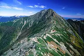 Mount Kita viewed from Mount Nakashirane | |
| Highest point | |
| Elevation | 3,193 m (10,476 ft)[1] |
| Prominence | 2,239 m (7,346 ft)[2] |
| Listing | 100 Famous Japanese Mountains Ultra |
| Coordinates | 35°40′27″N 138°14′12″E / 35.67417°N 138.23667°E[2] |
| Naming | |
| English translation | northern peak |
| Language of name | Japanese |
| Pronunciation | [ki̥tadake] |
| Geography | |
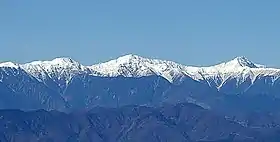
 Mount Kita Japan | |
| Location | Minami-Alps, Yamanashi Prefecture, Japan |
| Parent range | Akaishi Mountains |
| Topo map | Geographical Survey Institute (国土地理院, Kokudochiriin) 25000:1 仙丈ヶ岳, 50000:1 市野瀬 |
| Climbing | |
| Easiest route | Hike |
Mount Kita (北岳, Kita-dake) is a mountain of the Akaishi Mountains−"Southern Alps" (南アルプス Minami-Arupusu), in Yamanashi Prefecture, Japan.
It is the second tallest mountain in Japan, after Mount Fuji, and is known as "the Leader of the Southern Alps".[3] It is included in the 100 Famous Japanese Mountains. It is located in Minami Alps National Park, near the city of Minami-Alps,which in Yamanashi Prefecture.
Geography
The Kitadake Buttress (北岳バットレス, Kita-dake Battoresu) is a 600 m (1,969 ft) tall rock face on the eastern side of the mountain.
Alpine plants grow abundantly, especially on the mountain's southeastern slope along the route to Mount Nakashirane (中白峰山, Nakashirane-san) and along the Kusasuberi (草すべり, kusasuberi) and Migimata (右俣, migimata) courses along Shiraneo Pond (白根御池, Shiraneo-ike) on the mountain's northern side. Large clusters of plants can be seen from huts near the top. The species Callianthemum hondoense (キタダケソウ, kitadakesō) is endemic to this mountain.
See also
References
- ↑ Geographical Survey Institute map 25000:1 仙丈ヶ岳 accessed online 8 April 2008.
- 1 2 "Japan Ultra-Prominences". Peaklist.org. Retrieved 2015-01-01.
- ↑ Mount Kita Archived 2011-07-22 at the Wayback Machine. (in Japanese) Minami Alps Net. Accessed July 1, 2008.
External links
- Topographic map (1:25,000)
| Hokkaidō | |||||||||
|---|---|---|---|---|---|---|---|---|---|
| Tōhoku region Jōshinetsu region |
| ||||||||
| Kantō region | |||||||||
| Chūbu region |
| ||||||||
| Western Japan | |||||||||
| |||||||||