Kröslin | |
|---|---|
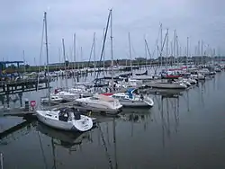 Marina in Kröslin | |
 Coat of arms | |
Location of Kröslin within Vorpommern-Greifswald district 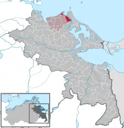 | |
 Kröslin  Kröslin | |
| Coordinates: 54°7′N 13°46′E / 54.117°N 13.767°E | |
| Country | Germany |
| State | Mecklenburg-Vorpommern |
| District | Vorpommern-Greifswald |
| Municipal assoc. | Lubmin |
| Subdivisions | 5 |
| Government | |
| • Mayor | Holger Dinse (CDU) |
| Area | |
| • Total | 22.41 km2 (8.65 sq mi) |
| Elevation | 2 m (7 ft) |
| Population (2021-12-31)[1] | |
| • Total | 1,758 |
| • Density | 78/km2 (200/sq mi) |
| Time zone | UTC+01:00 (CET) |
| • Summer (DST) | UTC+02:00 (CEST) |
| Postal codes | 17440 |
| Dialling codes | 038370 |
| Vehicle registration | VG |
| Website | www.kroeslin.de |
Kröslin is a municipality in the Vorpommern-Greifswald district, in Mecklenburg-Vorpommern, Germany. It consists of the villages
- Freest
- Hollendorf
- Karrin
- Kröslin
- Spandowerhagen
and the islands
- Greifswalder Oie
- Ruden
- Dänholm
- Großer Wotig
- Kleiner Wotig
- Großer Rohrplan.
References
- ↑ "Bevölkerungsstand der Kreise, Ämter und Gemeinden 2021" (XLS) (in German). Statistisches Amt Mecklenburg-Vorpommern. 2022.
External links
Wikimedia Commons has media related to Kröslin.
This article is issued from Wikipedia. The text is licensed under Creative Commons - Attribution - Sharealike. Additional terms may apply for the media files.