| Santo Lake | |
|---|---|
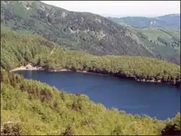 Image taken from mount Marmagna | |
 Santo Lake | |
| Location | Province of Parma, Emilia-Romagna |
| Coordinates | 44°24′07″N 10°00′25″E / 44.40194°N 10.00694°E |
| Type | glacial lake |
| Primary outflows | Parma di Lago Santo |
| Basin countries | Italy |
| Max. length | 430 m (1,410 ft) |
| Max. width | 220 m (720 ft) |
| Surface area | 0.0815 km2 (0.0315 sq mi) |
| Max. depth | 22.5 m (74 ft) |
| Shore length1 | 1.2 km (0.75 mi) |
| Surface elevation | 1,507 m (4,944 ft) |
| Frozen | Usually in January and February. Thickness from few cm up to 1 m. |
| 1 Shore length is not a well-defined measure. | |
Santo Lake is a lake in the Province of Parma, Emilia-Romagna, Italy. At an elevation of 1507 m, its surface area is 0.0815 km2.
Overview
The outflow is the small river Parma di Lago Santo. After about 4 km it join with Parma di Badignana and the river then takes the name of Parma.
This article is issued from Wikipedia. The text is licensed under Creative Commons - Attribution - Sharealike. Additional terms may apply for the media files.