Long Island, Virginia | |
|---|---|
Unincorporated community | |
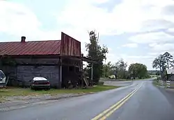 Westbound VSR 761 running through Long Island before crossing a former Norfolk and Western Railway line, and later the Staunton River. | |
 Long Island  Long Island | |
| Coordinates: 37°04′43″N 79°05′39″W / 37.07861°N 79.09417°W | |
| Country | United States |
| State | Virginia |
| County | Campbell |
| Elevation | 558 ft (170 m) |
| Time zone | UTC-5 (Eastern (EST)) |
| • Summer (DST) | UTC-4 (EDT) |
| Area code | 434 |
| GNIS feature ID | 1495868[1] |
Long Island is an unincorporated community in Campbell County, Virginia, United States. Long Island is located along the Roanoke River (also known as the Staunton River) east-southeast of Altavista.
The main road through the community is Virginia Secondary Route 761 (Long Island Road), and the community is almost entirely agricultural. A former Norfolk and Western Railway line runs through the community on the northeast bank of the Staunton River. A boat ramp exists south of VSR 761.[2]
Green Hill was listed on the National Register of Historic Places in 1969.[3]
References
![]() Media related to Long Island, Virginia at Wikimedia Commons
Media related to Long Island, Virginia at Wikimedia Commons
Municipalities and communities of Campbell County, Virginia, United States | ||
|---|---|---|
| Towns | 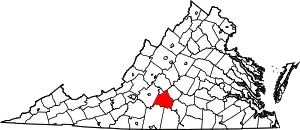 Map of Virginia highlighting Campbell County | |
| CDPs | ||
| Unincorporated communities | ||
| Footnotes | ‡This populated place also has portions in an adjacent county or counties | |
This article is issued from Wikipedia. The text is licensed under Creative Commons - Attribution - Sharealike. Additional terms may apply for the media files.