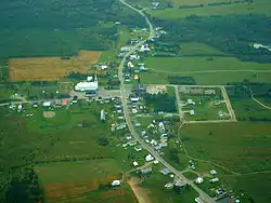
Saint-Eusèbe | |
|---|---|
 | |
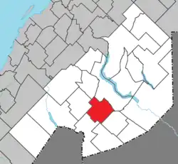 Location within Témiscouata RCM | |
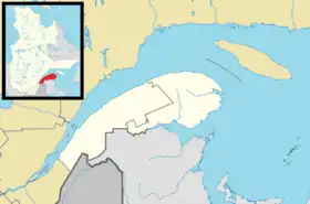 Saint-Eusèbe Location in eastern Quebec | |
| Coordinates: 47°33′N 68°55′W / 47.550°N 68.917°W[1] | |
| Country | |
| Province | |
| Region | Bas-Saint-Laurent |
| RCM | Témiscouata |
| Constituted | January 5, 1911 |
| Government | |
| • Mayor | Gaston Chouinard |
| • Federal riding | Rimouski-Neigette— Témiscouata—Les Basques |
| • Prov. riding | Rivière-du-Loup-Témiscouata |
| Area | |
| • Total | 131.00 km2 (50.58 sq mi) |
| • Land | 129.64 km2 (50.05 sq mi) |
| Population | |
| • Total | 593 |
| • Density | 4.6/km2 (12/sq mi) |
| • Pop 2011-2016 | |
| • Dwellings | 265 |
| Time zone | UTC−5 (EST) |
| • Summer (DST) | UTC−4 (EDT) |
| Postal code(s) | |
| Area code(s) | 418 and 581 |
| Highways | |
Saint-Eusèbe is a parish municipality in Quebec, Canada. It was established in 1911.[2]
Demographics
In the 2021 Census of Population conducted by Statistics Canada, Saint-Eusèbe had a population of 587 living in 244 of its 276 total private dwellings, a change of -1% from its 2016 population of 593. With a land area of 129.56 km2 (50.02 sq mi), it had a population density of 4.5/km2 (11.7/sq mi) in 2021.[4]
See also
References
- ↑ "Banque de noms de lieux du Québec: Reference number 56478". toponymie.gouv.qc.ca (in French). Commission de toponymie du Québec.
- 1 2 3 "Répertoire des municipalités, "Saint-Eusèbe"". Gouvernement du Québec. 2010. Retrieved December 21, 2011.
- 1 2 "Census Profile, 2016 Census - Saint-Eusèbe, Paroisse (Municipalité de) [Census subdivision], Quebec and Quebec [Province]". 8 February 2017.
- ↑ "Population and dwelling counts: Canada, provinces and territories, and census subdivisions (municipalities), Quebec". Statistics Canada. February 9, 2022. Retrieved August 29, 2022.
External links
 Media related to Saint-Eusèbe, Quebec at Wikimedia Commons
Places adjacent to Saint-Eusèbe, Quebec | |
|---|---|
| Cities & Towns | |
|---|---|
| Municipalities | |
| Parishes | |
| |
This article is issued from Wikipedia. The text is licensed under Creative Commons - Attribution - Sharealike. Additional terms may apply for the media files.