Mont-Blanc | |
|---|---|
 | |
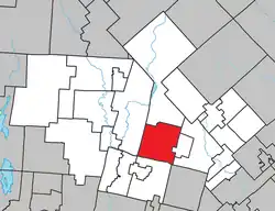 Location within Les Laurentides RCM. | |
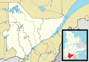 Mont-Blanc Location in central Quebec. | |
| Coordinates: 46°07′N 74°29′W / 46.117°N 74.483°W[1] | |
| Country | |
| Province | |
| Region | Laurentides |
| RCM | Les Laurentides |
| Constituted | January 3, 1996 |
| Name change[2] | January 29, 2022 |
| Named for | Mont-Blanc |
| Government | |
| • Mayor | Pierre Poirier |
| • Federal riding | Laurentides—Labelle |
| • Prov. riding | Labelle |
| Area | |
| • Total | 129.30 km2 (49.92 sq mi) |
| • Land | 121.28 km2 (46.83 sq mi) |
| Population (2011)[4] | |
| • Total | 3,467 |
| • Density | 28.6/km2 (74/sq mi) |
| • Pop 2006-2011 | |
| • Dwellings | 2,407 |
| Time zone | UTC−5 (EST) |
| • Summer (DST) | UTC−4 (EDT) |
| Postal code(s) | |
| Area code | 819 |
| Highways | |
| Website | mont-blanc |
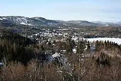
Mont-Blanc, is a municipality in the Laurentides region of Quebec, Canada, part of the Les Laurentides Regional County Municipality.
The municipality was formerly known as Saint-Faustin–Lac-Carré. The application to change the name to the Municipality of Mont-Blanc was approved by the Government of Quebec on January 14, 2022[2] and officially modified on January 29, 2022.[5]
History
In 1996, the municipality of Saint-Faustin–Lac-Carré was formed when the municipalities of Lac-Carré and Saint-Faustin merged. Its inhabitants were called Faustilacois and Faustilacoises.
Demographics
| 2016 | 2011 | |
|---|---|---|
| Population | 3,499 (+0.9% from 2011) | 3,467 (+16.1% from 2006) |
| Land area | 121.53 km2 (46.92 sq mi) | 121.28 km2 (46.83 sq mi) |
| Population density | 28.8/km2 (75/sq mi) | 28.6/km2 (74/sq mi) |
| Median age | 43.2 (M: 43.7, F: 42.8) | 42.8 (M: 43.1, F: 42.4) |
| Private dwellings | 2,517 (total) | 2,407 (total) |
| Median household income | $56,741 | $47,983 |
|
| |||||||||||||||
| Source: Statistics Canada | ||||||||||||||||
| Language | Population | Percentage (%) |
|---|---|---|
| French | 3,315 | 95% |
| English | 110 | 3% |
| Other | 25 | 1% |
| Language | Population | Percentage (%) |
|---|---|---|
| French | 3,300 | 94% |
| English | 105 | 3% |
| Other | 65 | 2% |
| Ethnicity | Population | Percentage (%) |
|---|---|---|
| Not a visible minority | 3,435 | 98% |
| Visible minorities | 50 | 1% |
Education
Sainte Agathe Academy (of the Sir Wilfrid Laurier School Board) in Sainte-Agathe-des-Monts serves English-speaking students in this community for both elementary and secondary levels.[10]
See also
References
- ↑ "Banque de noms de lieux du Québec: Reference number 312947". toponymie.gouv.qc.ca (in French). Commission de toponymie du Québec.
- 1 2 "Gazette Officielle du Québec" (PDF). Official Publisher of Quebec. January 29, 2022. Retrieved February 4, 2022.
J'approuve, conformément à l'article 25 de la Loi sur l'organisation territoriale municipale (chapitre O-9), en date du 14 janvier 2022, la demande de changement de nom de la Municipalité de Saint-Faustin–Lac-Carré, située dans la Municipalité régionale de comté des Laurentides, pour lui donner le nom de «Municipalité de Mont-Blanc».
- 1 2 "Répertoire des municipalités: Geographic code 78047". www.mamh.gouv.qc.ca (in French). Ministère des Affaires municipales et de l'Habitation.
- 1 2 "Mont-Blanc, Quebec (Code 2478047) Census Profile". 2011 census. Government of Canada - Statistics Canada.
- ↑ https://statistique.quebec.ca/statistiques/divisions-territoriales/bulletins/modifications-municipalites-janvier-2022.pdf
- ↑ "2016 Community Profiles". 2016 Canadian Census. Statistics Canada. August 12, 2021. Retrieved 2022-06-09.
- ↑ "2011 Community Profiles". 2011 Canadian Census. Statistics Canada. March 21, 2019. Retrieved 2022-06-09.
- ↑ "2006 Community Profiles". 2006 Canadian Census. Statistics Canada. August 20, 2019.
- ↑ "2001 Community Profiles". 2001 Canadian Census. Statistics Canada. July 18, 2021.
- ↑ "About Us." Saint Agathe Academy. Retrieved on September 4, 2017. See Elementary zone map and Secondary zone map - Note that all areas covered in the elementary map are also covered in the secondary one.
Places adjacent to Mont-Blanc, Quebec | |
|---|---|
| Cities/towns | |
|---|---|
| Municipalities | |
| Townships | |
| Villages | |
| |