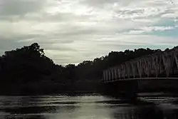
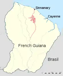
| Sinnamary | |
|---|---|
 | |
 | |
| Location | |
| Country | France |
| Territory | French Guiana |
| Physical characteristics | |
| Mouth | Atlantic Ocean |
• location | Sinnamary |
• coordinates | 5°26′14″N 52°59′47″W / 5.4373°N 52.9964°W |
| Length | 290 km (180 mi) |
| Designations | |
|---|---|
| Official name | Estuaire du fleuve Sinnamary |
| Designated | 15 September 2008 |
| Reference no. | 1828[1] |
The Sinnamary (French pronunciation: [sinamaʁi]) is a river in French Guiana. It is 290 km (180 mi) long.[2] It rises in the center of the country, flowing north until it reaches the Atlantic Ocean near the town of Sinnamary. Its longest tributary is the Koursibo.[2] The Petit-Saut Dam was built near Petit-Saut between 1989 and 1994.
References
- ↑ "Estuaire du fleuve Sinnamary". Ramsar Sites Information Service. Retrieved 25 April 2018.
- 1 2 Sandre. "Fiche cours d'eau - sinnamary, le (fleuve) (90--0200)".
This article is issued from Wikipedia. The text is licensed under Creative Commons - Attribution - Sharealike. Additional terms may apply for the media files.