Toribío | |
|---|---|
Municipality and town | |
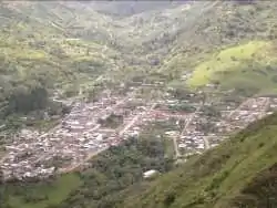 View of Toribío | |
 Flag  Seal | |
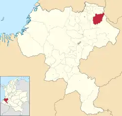 Location of the municipality and town of Toribío in the Cauca Department of Colombia | |
| Coordinates: 2°57′29″N 76°16′17″W / 2.95806°N 76.27139°W | |
| Country | |
| Department | Cauca Department |
| Area | |
| • Total | 399 km2 (154 sq mi) |
| Elevation | 1,701 m (5,581 ft) |
| Population (Census 2018[1]) | |
| • Total | 30,654 |
| Time zone | UTC-5 (Colombia Standard Time) |
| Climate | Am |
Toribío is a town and municipality in Cauca Department, Colombia. It is located at around 2°57′29″N 76°16′17″W / 2.95806°N 76.27139°W, in the elevation of about 2000 m.
References
- ↑ "Censo Nacional de Población y Vivienda 2018" (in Spanish). Retrieved 20 April 2020.
External links
- (in Spanish) Toribio official website
This article is issued from Wikipedia. The text is licensed under Creative Commons - Attribution - Sharealike. Additional terms may apply for the media files.