Houttuin | |
|---|---|
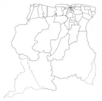
 Map showing the resorts of Wanica District. Houttuin | |
| Country |  Suriname Suriname |
| District | Wanica District |
| Area | |
| • Total | 58 km2 (22 sq mi) |
| Population (2012)[1] | |
| • Total | 15,656 |
| • Density | 270/km2 (700/sq mi) |
| Time zone | UTC-3 (AST) |
Houttuin is a resort in Suriname, located in the Wanica District. Its population at the 2012 census was 15,656. The largest ethnic group are the Indo-Surinamese.[1] The resort is named after the sugar plantation Houttuyn which was founded in 1737.[2] The resort was mainly agricultural,[3] and is planned to remain an agricultural centre.[4] In the early 21st century, it has seen a steady population growth, and is becoming suburban with housing projects like Tout Lui Faut.[4]
Staatsolie is operating an oil refinery,[5] and a thermal power plant in Houttuin.[6]
References
- 1 2 "Resorts in Suriname Census 2012" (PDF). Retrieved 23 May 2020.
- ↑ "Plantage Houttuin". Suriname Plantages (in Dutch). Retrieved 23 May 2020.
- ↑ "Geschiedenis". Wanica.nl (in Dutch). Retrieved 23 May 2020.
- 1 2 "Structuur Analyse IV" (PDF). Planning Office Suriname (in Dutch). Retrieved 23 May 2020.
- ↑ "Staatsolie's Tout Lui Faut Refinery Expansion". Hydro Carbons Technology. Retrieved 23 May 2020.
- ↑ "Bruto Omzet Staatsolie US 500 miljoen in 2019". Suriname.nu (in Dutch). Retrieved 23 May 2020.
This article is issued from Wikipedia. The text is licensed under Creative Commons - Attribution - Sharealike. Additional terms may apply for the media files.