U.S. Highway 6 | ||||
|---|---|---|---|---|
| Grand Army of the Republic Highway | ||||
US 6 highlighted in red | ||||
| Route information | ||||
| Maintained by CDOT | ||||
| Length | 467.284 mi[1] (752.021 km) | |||
| Major junctions | ||||
| West end |    I-70 / US 6 / US 50 at the Utah state line I-70 / US 6 / US 50 at the Utah state line | |||
| East end | US 6 at the Nebraska state line | |||
| Location | ||||
| Country | United States | |||
| State | Colorado | |||
| Counties | Mesa, Garfield, Eagle, Summit, Clear Creek, Jefferson, Denver, Adams, Weld, Morgan, Washington, Logan, Phillips | |||
| Highway system | ||||
| ||||
| ||||


U.S. Highway 6 (US 6) is a part of the United States Numbered Highway System that travels from Bishop, California, to Provincetown, Massachusetts. In the U.S. state of Colorado, US 6 is an east–west highway stretching from Utah to Nebraska. Much of the route overlaps other highways in Colorado, and, as a result, much of US 6 is unsigned.
Route description

US 6 is concurrent with Interstate 70 (I-70) for a significant portion of its length from the Utah state line to Denver. When the highway enters the western Denver suburbs, US 6 coincidentally aligns with 6th Avenue in the grid system, where it is known as 6th Avenue Freeway. Once it reaches I-25, US 6 travels north briefly, then follows I-76 for most of its length east of Denver. It is unsigned while it is overlapped.
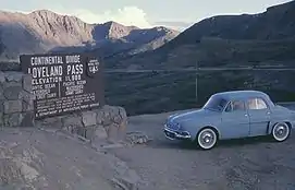
The highest altitude along US 6 is 11,990 feet (3,650 m) at Loveland Pass, where it crosses the Continental Divide. It continues down the Clear Creek valley until it reaches I-70, where it is briefly overlapped until I-70 leaves the Clear Creek valley. US 6 continues down Clear Creek and into Denver, where it turns into a freeway with six lanes. East of Denver, it continues east while joined with I-76 until it reaches Sterling, where it diverges from the Interstate. The last town in Colorado through which it passes is Holyoke.


History
Major intersections
| County | Location | mi[1] | km | Exit | Destinations | Notes |
|---|---|---|---|---|---|---|
| Mesa | | 0.000 | 0.000 |  I-70 west (US 6 / US 50 west) – Salina I-70 west (US 6 / US 50 west) – Salina | Continuation into Utah | |
| | 1.814 | 2.919 | 2 | Rabbit Valley | Exit number follows I-70 | |
| Mack | 11.106 | 17.873 |  I-70 east I-70 east | Eastern end of I-70 overlap; I-70 exit 11 | ||
| Loma | 15.132 | 24.353 |   SH 139 to I-70 – Loma, Rangely SH 139 to I-70 – Loma, Rangely | To I-70 via SH 139 south | ||
| Fruita | 19.955 | 32.114 |   SH 340 east (Coulson Street) to I-70 SH 340 east (Coulson Street) to I-70 | Western terminus of SH 340 | ||
| Grand Junction | 26.080 | 41.972 |   I-70 BL begins / I-70 – Denver, Utah I-70 BL begins / I-70 – Denver, Utah | Western end of I-70 BL overlap; I-70 exit 26; diverging diamond interchange | ||
| 28.244 | 45.454 | Patterson Road / 24 Road Redlands Parkway south | Partial interchange | |||
| 30.447 | 49.000 | I-70 BL / US 50 east – Montrose | Eastern end of I-70 BL/US 50 overlap; no westbound exit | |||
| 34.859 | 56.100 |  I-70 BL west I-70 BL west | Western end of I-70 BL overlap | |||
| Clifton | 37.267 | 59.975 |   SH 141 south SH 141 south | Northern terminus of SH 141 | ||
| 37.726 | 60.714 |  I-70 BL east to I-70 – Utah, Denver I-70 BL east to I-70 – Utah, Denver | Eastern end of I-70 BL overlap | |||
| | 46.510 43.682 | 74.851 70.299 | I-70 west | Western end of I-70 overlap; I-70 exit 44; westbound left exit and eastbound left entrance; mileposts change to reflect I-70 mileage | ||
| | 45.332 | 72.955 | 46 | Cameo | Exit numbers follow I-70 | |
| | 46.867 | 75.425 | 47 | James M. Robb – Colorado River State Park, Island Acres | Former port of entry | |
| | 49.015 | 78.882 | 49 |    SH 65 south to SH 330 east – Grand Mesa, Collbran SH 65 south to SH 330 east – Grand Mesa, Collbran | ||
| | 61.648 64.249 | 99.213 103.399 | I-70 east | Eastern end of I-70 overlap;[2] I-70 exit 62; mileposts change to reflect US 6 mileage | ||
| Garfield | Parachute | 72.284– 72.688 | 116.330– 116.980 | I-70 / Frontage Road | Dumbbell interchange; I-70 exit 72 | |
| Rifle | 88.895 | 143.063 | I-70 | I-70 exit 87 | ||
| 91.240 | 146.837 |   SH 13 north – Meeker, Craig SH 13 north – Meeker, Craig | East end of state maintenance;[3] west end of SH 13 overlap | |||
| SH 13 south to I-70 | East end of SH 13 overlap; westbound access via Whiteriver Avenue | |||||
| Chacra | 110.806 109.000 | 178.325 175.418 | I-70 west | West end of state maintenance;[3] western end of I-70 overlap; I-70 exit 109; mileposts change to reflect I-70 mileage | ||
| | 111.328 | 179.165 | 111 | South Canyon | Exit number follows I-70 | |
| Glenwood Springs | 114.295 116.898 | 183.940 188.129 | I-70 east / Gilstrap Court / Midland Avenue / Mel Ray Road / Highway 6 west – Glenwood Springs Mall | Dumbbell interchange; east end of state maintenance; Highway 6 west is former US 6/ US 24 west; I-70 exit 114; mileposts change to reflect US 6 mileage | ||
| 118.645 | 190.941 | Devereaux Road | West end of state maintenance[4] | |||
| 118.983 116.380 | 191.485 187.295 |  SH 82 east (Grand Avenue) / I-70 west / E. 6th Street / Laurel Street – Aspen SH 82 east (Grand Avenue) / I-70 west / E. 6th Street / Laurel Street – Aspen | Partial dumbbell interchange with I-70; western end of I-70 overlap; I-70 exit 116; western terminus of SH 82; mileposts change to reflect I-70 mileage | |||
| | 118.640 | 190.933 | 119 | No Name | Exit numbers follow I-70 | |
| | 120.954 | 194.657 | 121 | Grizzly Creek to Hanging Lake | Hanging Lake appears only on westbound signage | |
| | 122.660 | 197.402 | 123 | Shoshone | Eastbound exit and westbound entrance | |
| | 125.061 | 201.266 | 125 | Hanging Lake | Eastbound exit and westbound entrance | |
| | 125.269 | 201.601 | Hanging Lake Tunnel | |||
| | 128.317 | 206.506 | 129 | Bair Ranch Road | ||
| Eagle | | 133.384– 134.053 | 214.661– 215.737 | 133 | Dotsero | |
| Gypsum | 139.533 141.818 | 224.557 228.234 | I-70 east – Denver | Eastern end of I-70 overlap; I-70 exit 140; mileposts change to reflect US 6 mileage | ||
| 141.993 | 228.516 | Frontage Road / Trail Gulch Road | Roundabout; east end of state maintenance;[5] Frontage Rd. is former US 6 west | |||
| Eagle | 149.718 | 240.948 | Church Street / Eby Creek Road (I-70 BS north) to I-70 | Roundabout; west end of state maintenance;[6] southern terminus of I-70 BS | ||
| Wolcott | 159.500 | 256.690 |  SH 131 north – Steamboat Springs SH 131 north – Steamboat Springs | Western end of SH 131 overlap | ||
| | 159.889 | 257.316 | SH 131 south to I-70 | Eastern end of SH 131 overlap | ||
| Eagle-Vail | 172.185 | 277.105 | I-70 east | I-70 east exit 169; no access to I-70 west | ||
| | 174.541 171.105 | 280.897 275.367 | I-70 west – Aspen US 24 east – Minturn, Leadville US 24 east – Minturn, Leadville | Western end of I-70 overlap; I-70 exit 171; western terminus of US 24; mileposts change to reflect I-70 mileage | ||
| Vail | 173.319 | 278.930 | 173 | West Vail | Exit numbers follow I-70 | |
| 176.057 | 283.336 | 176 | Vail Ski Area – Vail Museum | |||
| 179.866 | 289.466 | 180 | East Vail | |||
| Vail Pass | 189.981 | 305.745 | Elevation 10,662 feet (3,250 m) | |||
| Summit | | 190.095 | 305.928 | 190 | Shrine Pass Road – Vail Pass rest area | |
| | 195.298 | 314.302 | 195 |  SH 91 south – Copper Mountain, Leadville SH 91 south – Copper Mountain, Leadville | Northern terminus of SH 91 | |
| | 197.854 | 318.415 | 198 | Officers Gulch | ||
| Frisco | 200.995 | 323.470 | 201 | Main Street | ||
| 202.352 | 325.654 | 203 |  SH 9 south – Frisco, Breckenridge SH 9 south – Frisco, Breckenridge | Western end of SH 9 overlap | ||
| Silverthorne | 205.423 208.659 | 330.596 335.804 | SH 9 north (Blue River Parkway) / I-70 east – Silverthorne | Eastern end of I-70/SH 9 overlap; I-70 exit 205; mileposts change to reflect US 6 mileage | ||
| Loveland Pass | 225.552 | 362.991 | Elevation 11,990 feet (3,650 m) | |||
| Clear Creek | | 229.896 216.185 | 369.982 347.916 | I-70 west – Grand Junction | Western end of I-70 overlap; mileposts change to reflect I-70 mileage | |
| | 218.346 | 351.394 | 218 | Herman Gulch Road | Exit numbers follow I-70 | |
| | 221.297 | 356.143 | 221 | Bakerville | ||
| Silver Plume | 225.719 | 363.260 | 226 | Silver Plume | ||
| Georgetown | 227.910 | 366.786 | 228 | Georgetown | ||
| | 231.889 | 373.189 | 232 |   US 40 west – Empire, Granby US 40 west – Empire, Granby | Western end of US 40 overlap | |
| | 223.047 | 358.959 | 223 | Lawson | Eastbound exit only | |
| | 234.209 | 376.923 | 234 | Downieville, Lawson | ||
| | 235.005 | 378.204 | 235 | Dumont | Westbound exit and eastbound entrance | |
| | 237.680 | 382.509 | 238 | Fall River Road | ||
| Idaho Springs | 238.885 | 384.448 | 239 | I-70 BL east – Idaho Springs | ||
| 239.652 | 385.683 | 240 |  SH 103 south / Mount Evans Scenic Byway – Mount Evans SH 103 south / Mount Evans Scenic Byway – Mount Evans | Northern terminus of SH 103 | ||
| 241.125 | 388.053 | 241 | I-70 BL west / County Road 314 | |||
| | 242.980 | 391.038 | 243 | Hidden Valley, Central City | ||
| | 244.260 257.079 | 393.098 413.729 | I-70 – Denver | Interchange; eastern end of I-70 overlap; I-70 exit 244; no ramp to I-70 east.; mileposts change to reflect US 6 mileage | ||
| | 257.296 | 414.078 | US 40 east to I-70 east | Eastern end of US 40 overlap | ||
| | 257.751 | 414.810 |  SH 119 north – Black Hawk, Central City SH 119 north – Black Hawk, Central City | Southern terminus of SH 119 | ||
| Jefferson | Golden | 271.600 | 437.098 |   SH 58 east / SH 93 north – Golden, Boulder SH 58 east / SH 93 north – Golden, Boulder | Western terminus of SH 58 | |
| 273.397 | 439.990 |  SH 470 east – Colorado Springs SH 470 east – Colorado Springs | SH 470 exits 0A-B northbound | |||
| 275.120 | 442.763 | US 40 (Colfax Avenue) | ||||
| 276.003 | 444.184 | — | I-70 west – Grand Junction | West end of 6th Avenue freeway; westbound exit and eastbound entrance; I-70 exit 261 eastbound | ||
| Lakewood | 276.998 | 445.785 | — | Indiana Street | ||
| 277.002 | 445.792 | — | Union Boulevard / Simms Street | |||
| 277.310 | 446.287 | — |  SH 391 (Kipling Street) SH 391 (Kipling Street) | |||
| 278.795 | 448.677 | — | Garrison Street | |||
| 280.830 | 451.952 | — |  SH 121 (Wadsworth Blvd) SH 121 (Wadsworth Blvd) | |||
| 281.984 | 453.809 | — |  SH 95 (Sheridan Blvd) SH 95 (Sheridan Blvd) | |||
| 282.330 | 454.366 | — | Knox Court | |||
| City and County of Denver | 283.86 | 456.83 | — |  SH 88 (Federal Blvd) / Bryant Street SH 88 (Federal Blvd) / Bryant Street | ||
| 284.470 209.210 | 457.810 336.691 | — | 6th Avenue east | No westbound exit; I-25 exit 209A; 6th Avenue freeway continues east | ||
| — |   I-25 south (US 85 / US 87 south) – Colorado Springs I-25 south (US 85 / US 87 south) – Colorado Springs | West end of I-25/US 85/US 87 overlap; I-25 exit 209B; mileposts change to reflect I-25 mileage | ||||
| 209.479 | 337.124 | 209C | 8th Avenue | Exit numbers follow I-25 | ||
| 210.310 | 338.461 | 210A |  US 40 / US 287 (Colfax Avenue) – Downtown Denver US 40 / US 287 (Colfax Avenue) – Downtown Denver | |||
| 210.415 | 338.630 | 210B | Auraria Parkway | Eastbound exit and westbound entrance | ||
| 210.532 | 338.818 | 210C | 17th Avenue | Eastbound exit and entrance; westbound access is via exit 211 | ||
| 211.109 | 339.747 | 211 | 23rd Avenue / 20th Avenue | 20th Ave. not signed eastbound | ||
| 211.464 | 340.318 | 212A-B | Speer Boulevard – Downtown Denver | Signed as exits 212A (south) and 212B (north) | ||
| 212.096 | 341.335 | 212C | 20th Street | |||
| — | I-25 HOV/toll lanes | South end of I-25 reversible HOV/toll lanes; eastbound exit and westbound entrance | ||||
| 212.769 | 342.419 | 213 | Park Avenue / W. 38th Avenue | |||
| 213.625 274.062 | 343.796 441.060 | — |  I-25 north (US 87 north) – Thornton, Ft. Collins I-25 north (US 87 north) – Thornton, Ft. Collins | East end of I-25/US 87 overlap; I-25 exit 214A | ||
| — | I-70 west – Grand Junction | Western end of I-70 overlap; I-70 exit 274; mileposts change to reflect I-70 mileage | ||||
| 274.607 | 441.937 | 275A | Washington Street | No exit number eastbound; exit numbers follow I-70 | ||
| 275.252 | 442.975 | 275B |  SH 265 north (Brighton Boulevard) SH 265 north (Brighton Boulevard) | |||
| 275.545 | 443.447 | 275C | York Street / Josephine Street | Eastbound exit and westbound entrance | ||
| 276.080 290.98 | 444.308 468.29 | I-70 east | Eastern end of I-70 overlap; I-70 exit 276A; mileposts change to reflect US 6 mileage | |||
| Adams | Commerce City | 292.145 | 470.162 |  SH 2 south (Colorado Blvd) to I-70 east SH 2 south (Colorado Blvd) to I-70 east | Interchange; western end of SH 2 overlap; westbound exit and eastbound entrance | |
| 292.743 | 471.124 |  I-270 (US 36) – Boulder, Limon I-270 (US 36) – Boulder, Limon | Partial cloverleaf interchange; no eastbound exit to I-270 east; I-270 exits 2A-B | |||
| 293.42 | 472.21 | SH 2 east (Old) | Interchange; no westbound exit; eastern end of SH 2 overlap; no CDOT maintenance on this stretch of SH 2 | |||
| 293.763 | 472.766 | Mill Road | Interchange | |||
| 294.235– 294.651 | 473.525– 474.195 | SH 265 south | ||||
| 295.000 | 474.756 |   SH 224 west (74th Avenue) to I-76 west SH 224 west (74th Avenue) to I-76 west | ||||
| | 296.32 9.483 | 476.88 15.261 | I-76 west – Arvada | Interchange; western end of I-76 overlap; westbound left exit and eastbound left entrance; I-76 exit 9; mileposts change to reflect I-76 mileage | ||
| | 10.466 | 16.843 | 10 | 88th Avenue | Exit numbers follow I-76 | |
| | 11.549 | 18.586 | 11 | 96th Avenue | ||
| | 12.502 | 20.120 | 12 |  US 85 north – Greeley, Brighton US 85 north – Greeley, Brighton | Eastern end of US 85 overlap; no eastbound entrance | |
| Brighton | 16.477 | 26.517 | 16 | SH 2 south (Sable Boulevard) / 120th Avenue – Denver International Airport | ||
| 18.079 | 29.095 | 18 |   E-470 south to I-70 east – Limon, Denver International Airport E-470 south to I-70 east – Limon, Denver International Airport | Westbound exit and eastbound entrance; E-470 exit 35 | ||
| 19.723 | 31.741 | 20 | 136th Avenue | |||
| 21.081 | 33.927 | 21 | Eagle Boulevard | |||
| 22.407 | 36.061 | 22 | Bromley Lane | |||
| Adams–Weld county line | Lochbuie | 25.145 | 40.467 | 25 |  SH 7 west – Lochbuie, Brighton SH 7 west – Lochbuie, Brighton | |
| Weld | Hudson | 31.480 | 50.662 | 31 |  SH 52 – Hudson, Fort Lupton SH 52 – Hudson, Fort Lupton | |
| 34.412 | 55.381 | 34 | Kersey Road | |||
| | 38.925 | 62.644 | 39 | Keenesburg ( I-76 BS) | ||
| | 47.972 | 77.203 | 48 | Roggen | ||
| | 49.236 | 79.238 | 49 | Painter Road | Westbound exit and eastbound entrance | |
| | 57.219 | 92.085 | 57 | County Road 91 | ||
| | 59.799 | 96.237 | 60 |  SH 144 east – Orchard SH 144 east – Orchard | ||
| Morgan | | 63.883 343.519 | 102.810 552.840 | I-76 east | Eastern end of I-76 overlap;[7] no westbound access to I-76 east; I-76 exit 64; mileposts change to reflect US 6 mileage | |
| | 345.928 | 556.717 |  SH 52 west / SH 39 north to I-76 west – Goodrich, Hoyt SH 52 west / SH 39 north to I-76 west – Goodrich, Hoyt | Western end of SH 52 overlap; southern terminus of SH 39 | ||
| | 346.425 66.288 | 557.517 106.680 | 66B | I-76 west US 34 west – Greeley, Estes Park US 34 west – Greeley, Estes Park | Exit number is for US 34; exit numbers follow I-76; western end of I-76/US 34 overlap;[7] I-76 exit 66A; mileposts change to reflect I-76 mileage | |
| | 73.130 | 117.691 | 73 | Long Bridge Road | ||
| | 75.280 | 121.151 | 75 |  I-76 BL / US 34 east (SH 52 east) – Fort Morgan I-76 BL / US 34 east (SH 52 east) – Fort Morgan | Eastern end of US 34/SH 52 overlap; western terminus of I-76 BL | |
| | 78.852 | 126.900 | 79 | SH 144 – Weldona | ||
| Fort Morgan | 80.139 | 128.971 | 80 | SH 52 – Raymer, Fort Morgan | ||
| 81.648 | 131.400 | 82 | Barlow Road – Fort Morgan | |||
| | 85.713 | 137.942 | 86 | Dodd Bridge Road | ||
| | 88.695 | 142.741 | 89 | Hospital Road | ||
| Brush | 89.643 | 144.266 | 90 |  SH 71 to US 34 (I-76 BL) – Brush, Akron, Limon, Snyder SH 71 to US 34 (I-76 BL) – Brush, Akron, Limon, Snyder | ||
| | 91.693 371.69 | 147.566 598.18 | I-76 east / I-76 BL west (US 34 Spur south) to US 34 / SH 71 – Brush | Eastern end of I-76 overlap; western end of I-76 BL overlap; I-76 exit 92; mileposts change to reflect US 6 mileage; US 34 Spur unsigned | ||
| Washington | | 383.254 | 616.788 | County Road Q to I-76 | ||
| Logan | Atwood | 397.955 | 640.446 |  SH 63 south – Akron SH 63 south – Akron | Northern terminus of SH 63 | |
| Sterling | 404.644 | 651.211 |   US 138 east (3rd Street north) / SH 14 west (Chestnut Street west) – Julesburg, Fort Collins US 138 east (3rd Street north) / SH 14 west (Chestnut Street west) – Julesburg, Fort Collins | SH 14 is former US 6 west; western terminus of SH 138; eastern terminus of SH 14 | ||
| 404.734 | 651.356 | Front Street | Interchange; no westbound entrance | |||
| 406.568 | 654.308 |  I-76 BL ends / I-76 – Fort Morgan, Julesburg I-76 BL ends / I-76 – Fort Morgan, Julesburg | Eastern terminus of I-76 BL; eastern end of I-76 BL overlap; I-76 exit 125 | |||
| | 406.794 | 654.671 |  SH 61 south – Otis SH 61 south – Otis | Northern terminus of SH 61 | ||
| Fleming | 424.964 | 683.913 |  SH 55 north (Logan Avenue) SH 55 north (Logan Avenue) | Southern terminus of SH 55 | ||
| Phillips | Haxtun | 436.496 | 702.472 |  SH 59 – Yuma, Sedgwick SH 59 – Yuma, Sedgwick | ||
| Holyoke | 454.06 | 730.74 |  US 385 (Interocean Avenue) US 385 (Interocean Avenue) | |||
| | 467.284 | 752.021 | US 6 east – Imperial | Continuation into Nebraska | ||
| 1.000 mi = 1.609 km; 1.000 km = 0.621 mi | ||||||
References
- 1 2 Colorado Department of Transportation, Highway Data Archived October 8, 2007, at the Wayback Machine, accessed July 2007
- ↑ "Highway 006M between 62.305 and 88.895". CDOT Online Transportation Information System. Retrieved March 27, 2021.
- 1 2 "SPECIAL COMMITTEE ON U.S. ROUTE NUMBERING SPRING 2015 REPORT TO THE STANDING COMMITTEE ON HIGHWAYS" (PDF). AASHTO. May 14, 2015. p. 2. Retrieved March 26, 2021.
- ↑ "Highway 006K between 0 and 0.338". CDOT Online Transportation Information System. Retrieved March 27, 2021.
- ↑ "Highway 006N between 141.818 and 141.993". CDOT Online Transportation Information System. Retrieved March 27, 2021.
- ↑ "Highway 006E between 149.718 and 174.541". CDOT Online Transportation Information System. Retrieved March 27, 2021.
- 1 2 "Highway 006I between 343.519 and 346.697". CDOT Online Transportation Information System. Retrieved March 28, 2021.