| Vytebet | |
|---|---|
 | |
| Native name | Вытебеть (Russian) |
| Location | |
| Country | Russia |
| Physical characteristics | |
| Source | |
| • location | Yakovleva, Bryansk Oblast |
| • coordinates | 53°6′26″N 35°13′40″E / 53.10722°N 35.22778°E |
| • elevation | 210 m (690 ft) |
| Mouth | Zhizdra |
• coordinates | 53°53′4″N 35°38′14″E / 53.88444°N 35.63722°E |
• elevation | 140 m (460 ft) |
| Length | 133 km (83 mi) |
| Basin size | 1,760 km2 (680 sq mi) |
| Basin features | |
| Progression | Zhizdra→ Oka→ Volga→ Caspian Sea |
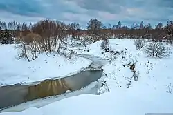
The Vytebet (Russian: Вытебеть) is a river that flows through the Bryansk, Oryol, and Kaluga Oblasts in Russia. The river is a right tributary of the Zhizdra, and its total length is 133 kilometers (83 mi) with a drainage basin of 1,760 square kilometers (680 sq mi).[1]
The Vytebet flows through the Orlovskoye Polesye National Park.[2]
References
- ↑ "Река ВЫТЕБЕТЬ" [Vytebet River]. State Water Register (in Russian). Retrieved 12 June 2017.
- ↑ "National Park Orlovskoye Polesye". www.rusnature.info. Retrieved 2017-06-12.
This article is issued from Wikipedia. The text is licensed under Creative Commons - Attribution - Sharealike. Additional terms may apply for the media files.