Šumadija and Western Serbia Шумадија и западна Србија Šumadija i zapadna Srbija | |
|---|---|
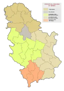 Location of Šumadija and Western Serbia (yellow) in Serbia | |
| Country |  Serbia Serbia |
| Founded | May 2010 |
| Largest city | Kragujevac |
| Area | |
| • Total | 26,493 km2 (10,229 sq mi) |
| Population (2022 census) | |
| • Total | 1,819,318 |
| • Density | 69/km2 (180/sq mi) |
| Preliminary results[2] | |
| GDP | |
| • Total | RSD 940.633 billion €8.0 billion (2018) |
| • Per capita | RSD 489,000 €4,100 (2018) |
| Districts | 8 |
| Settlements | 2,112 |
| HDI (2019) | 0.795[4] high · 3rd in Serbia |
The Šumadija and Western Serbia (Serbian: Шумадија и западна Србија / Šumadija i zapadna Srbija) is one of the five statistical regions of Serbia. It is also a level-2 statistical region according to the Nomenclature of Territorial Units for Statistics (NUTS). It was formed in 2010. As of 2022 census, the regions has a total of 1,819,318 inhabitants.[2]
Formation
In July 2009, the Serbian parliament adopted a new law in which Serbia was divided into seven statistical regions.[5] According to the law, territory of present-day Šumadija and Western Serbia was divided into two statistical regions – Western Region (Serbian: Западни регион, romanized: Zapadni region) and Central Region (Serbian: Централни регион, romanized: Centralni region).
However, in May 2010, the law was modified and Western and Central region were merged into a single statistical region whose name is Šumadija and Western Serbia.
Districts
The statistical region of Šumadija and Western Serbia is composed of 8 administrative districts:
| District | Area (km2) | Population (2011 Census) |
Administrative Capital | |
|---|---|---|---|---|
| Mačva | 3,264 | 265,377 | Šabac | |
| Kolubara | 2,474 | 154,497 | Valjevo | |
| Moravica | 3,016 | 189,281 | Čačak | |
| Zlatibor | 6,142 | 254,659 | Užice | |
| Šumadija | 2,387 | 269,728 | Kragujevac | |
| Pomoravlje | 2,614 | 182,047 | Jagodina | |
| Raška | 3,922 | 296,532 | Kraljevo | |
| Rasina | 2,664 | 207,197 | Kruševac | |
Source: Statistical Office of Serbia | ||||
Demographic structure
| Ethnic group | 2022 census | percentage % |
|---|---|---|
| Serbs | 1,629,310 | 89.55% |
| Bosniaks | 151,374 | 8.32% |
| Romani people | 17,167 | 0.94% |
| Muslims (ethnic group) | 7,559 | 0.41% |
| Total | 1,819,318 | 100% |
Cities and towns
The largest cities and towns of the region are:
| City or town | Population (2011 Census)[6] |
|---|---|
| Kragujevac | 150,835 |
| Čačak | 73,331 |
| Kruševac | 73,316 |
| Novi Pazar | 66,527 |
| Kraljevo | 64,175 |
| Valjevo | 59,073 |
| Šabac | 53,919 |
| Užice | 52,593 |
| Jagodina | 37,282 |
| Paraćin | 25,104 |
| Aranđelovac | 24,797 |
| Loznica | 24,363 |
| Gornji Milanovac | 24,216 |
| Trstenik | 15,282 |
References
- ↑ "Региони у Републици Србији" (PDF). stat.gov.rs (in Serbian). Statistical Office of Serbia. 16 October 2019. Retrieved 16 October 2019.
- 1 2 "Први резултати Пописa становништва, домаћинстава и станова 2022". stat.gov.rs (in Serbian). Statistical Office of Serbia. 21 December 2022. Retrieved 21 December 2022.
- ↑ "REGIONAL GROSS DOMESTIC PRODUCT Regions and areas of the Republic of Serbia, 2018" (PDF).
- ↑ "Sub-national HDI – Area Database – Global Data Lab". hdi.globaldatalab.org. Retrieved 2021-07-19.
- ↑ "Uvedeno sedam statističkih regiona". B92.net. 2009-07-08. Retrieved 2016-12-21.
- ↑ "Serbia: Regions, Districts and Major Cities – Population Statistics, Maps, Charts, Weather and Web Information".
External links

 | ||