Árneshreppur | |
|---|---|
 Coat of arms | |
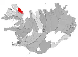 Location of Árneshreppur | |
 Árneshreppur | |
| Coordinates: 65°58′48″N 21°27′11″W / 65.980°N 21.453°W | |
| Country | Iceland |
| Region | Westfjords |
| Constituency | Northwest Constituency |
| Area | |
| • Total | 707 km2 (273 sq mi) |
| Population | |
| • Total | 53 |
| • Density | 0.07/km2 (0.2/sq mi) |
| Postal code(s) | 524 |
| Municipal number | 4901 |
Árneshreppur (Icelandic pronunciation: [ˈaurˌnɛsˌr̥ɛhpʏr̥] ⓘ) is an Icelandic municipality, located in the Westfjords peninsula of northwestern Iceland.[1]
The village Djúpavík at the Reykjarfjörður [ˈreiːcarˌfjœrðʏr̥] is situated in the municipality. Other villages are Gjögur [ˈcœːɣʏr̥], Norðurfjörður [ˈnɔrðʏrˌfjœrðʏr̥] and Krossnes [ˈkʰrɔsːˌnɛːs]. The area is served by Gjögur Airport.
References
- ↑ "Árneshreppur", Iceland Review. Accessed 14 June 2016.
This article is issued from Wikipedia. The text is licensed under Creative Commons - Attribution - Sharealike. Additional terms may apply for the media files.