| Černý potok | |
|---|---|
 | |
| Location | |
| Country | Czech Republic |
| Physical characteristics | |
| Source | |
| • location | Jizera Mountains |
| Mouth | |
• location | Smědá |
• coordinates | 50°52′26″N 15°12′01″E / 50.8739°N 15.2003°E |
| Basin features | |
| Progression | Smědá→ Lusatian Neisse→ Oder→ Baltic Sea |
The Černý potok is a tributary on the left side of the river Smědá in Liberec District in Liberec Region, Czech Republic. The stream flows for 5.1 km,[1] with a basin area measuring 6.7 km ².[2]
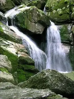
The stream rises on the northern slopes of Černé Mountain (1085 m) in the Jizera Mountains at an altitude of 1035 m. The average flow at the mouth is 0.16 m³ / s. It flows mainly north. During its relatively short flow creates innumerable waterfalls and cascades. The outflow rushes through a stream northwards through, where there is the forest, dividing into several branches to the Strašice.[3]
References
This article is issued from Wikipedia. The text is licensed under Creative Commons - Attribution - Sharealike. Additional terms may apply for the media files.