Řehenice | |
|---|---|
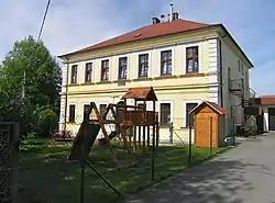 Municipal office and kindergarten | |
 Flag  Coat of arms | |
 Řehenice Location in the Czech Republic | |
| Coordinates: 49°52′11″N 14°39′1″E / 49.86972°N 14.65028°E | |
| Country | |
| Region | Central Bohemian |
| District | Benešov |
| First mentioned | 1384 |
| Area | |
| • Total | 11.04 km2 (4.26 sq mi) |
| Elevation | 321 m (1,053 ft) |
| Population (2023-01-01)[1] | |
| • Total | 507 |
| • Density | 46/km2 (120/sq mi) |
| Time zone | UTC+1 (CET) |
| • Summer (DST) | UTC+2 (CEST) |
| Postal codes | 251 67, 251 68 |
| Website | www |
Řehenice is a municipality and village in Benešov District in the Central Bohemian Region of the Czech Republic. It has about 500 inhabitants.
Administrative parts
Villages and hamlets of Babice, Barochov, Gabrhele, Křiváček, Malešín and Vavřetice are administrative parts of Řehenice.
Gallery
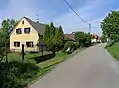 Eastern part of Řehenice
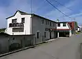 Restaurant in Řehenice
 The village of Křiváček
References
Wikimedia Commons has media related to Řehenice.
This article is issued from Wikipedia. The text is licensed under Creative Commons - Attribution - Sharealike. Additional terms may apply for the media files.