Šija | |
|---|---|
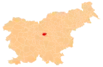
 Šija Location in Slovenia | |
| Coordinates: 46°9′35″N 14°47′5″E / 46.15972°N 14.78472°E | |
| Country | |
| Traditional region | Upper Carniola |
| Statistical region | Central Slovenia |
| Municipality | Moravče |
| Elevation | 705 m (2,313 ft) |
Šija (Slovene pronunciation: [ˈʃiːja]) is a former settlement in the Municipality of Moravče in central Slovenia. It is now part of the village of Limbarska Gora.[1][2] The area is part of the traditional region of Upper Carniola. The municipality is now included in the Central Slovenia Statistical Region.[3]
Geography
Šija lies in the eastern part of the village of Limbarska Gora, on the eastern slope of the hill ascending to the main settlement.[1]
History
Šija had a population of 14 living in two houses in 1900.[4] Šija was annexed by Limbarska Gora (at that time still called Sveti Valentin) in 1952, ending its existence as an independent settlement.[5][6]
References
- 1 2 Topole, Maja (2003). Geografija občine Moravče. Ljubljana: Založba ZRC. p. 193.
- ↑ Savnik, Roman (1971). Krajevni leksikon Slovenije, vol. 2. Ljubljana: Državna založba Slovenije. p. 92.
- ↑ E-občina. "Občina Moravče" [Moravče municipal site]. moravce.si. Retrieved 2022-03-29.
- ↑ Leksikon občin kraljestev in dežel zastopanih v državnem zboru, vol. 6: Kranjsko. Vienna: C. Kr. Dvorna in Državna Tiskarna. 1906. p. 19.
- ↑ Marinković, Dragan (1991). Abecedni spisak naselja u SFRJ. Promene u sastavu i nazivima naselja za period 1948–1990. Belgrade: Savezni zavod za statistiku. pp. 101, 104.
- ↑ Razširjeni seznam sprememb naselij: od 1948 do 1964: (poimenovanja, združevanja, odcepitve, pristavki, razglastive in ukinitve). Ljubljana: Zavod SR Slovenije za statistiko. 1965. p. 107.
External links
![]() Media related to Šija at Wikimedia Commons
Media related to Šija at Wikimedia Commons
This article is issued from Wikipedia. The text is licensed under Creative Commons - Attribution - Sharealike. Additional terms may apply for the media files.