Špičnik | |
|---|---|
.jpg.webp) | |
 Špičnik Location in Slovenia | |
| Coordinates: 46°39′57.88″N 15°34′5.64″E / 46.6660778°N 15.5682333°E | |
| Country | |
| Traditional region | Styria |
| Statistical region | Drava |
| Municipality | Kungota |
| Area | |
| • Total | 2.68 km2 (1.03 sq mi) |
| Elevation | 339 m (1,112 ft) |
| Population (2002) | |
| • Total | 120 |
| [1] | |
Špičnik (pronounced [ˈʃpiːtʃnik]) is a dispersed settlement in the western Slovene Hills (Slovene: Slovenske gorice) in the Municipality of Kungota in northeastern Slovenia, next to the border with Austria.[2]
References
External links
| Settlements | 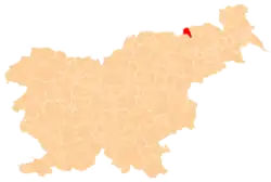 | |
|---|---|---|
| Landmarks |
| |
This article is issued from Wikipedia. The text is licensed under Creative Commons - Attribution - Sharealike. Additional terms may apply for the media files.