Štefanov | |
|---|---|
Village | |
 | |
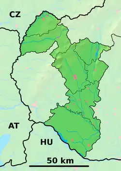 Štefanov Location of Štefanov in the Trnava Region  Štefanov Štefanov (Slovakia) | |
| Coordinates: 48°41′N 17°12′E / 48.683°N 17.200°E | |
| Country | Slovakia |
| Region | Trnava |
| District | Senica |
| First mentioned | 1392 |
| Area | |
| • Total | 22.08[1] km2 (8.53[1] sq mi) |
| Elevation | 187[2] m (614[2] ft) |
| Population (2021) | |
| • Total | 1,630[3] |
| Postal code | 906 45[2] |
| Area code | +421 34[2] |
| Car plate | SE |
| Website | www.stefanovobec.sk |

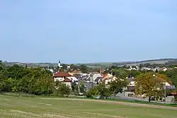
Church
Štefanov (Hungarian: Csépányfalva) is a village and municipality in Senica District in the Trnava Region of western Slovakia.
History
In historical records the village was first mentioned in 1392. The church in the village is a Catholic Church built in 1937.[4]
Geography
The municipality lies at an altitude of 205 metres and covers an area of 22.088 km². It has a population of about 1,621 people. It is located in the Záhorie region of Western Slovakia, on the edge between plains and hills.
References
- 1 2 "Hustota obyvateľstva - obce [om7014rr_ukaz: Rozloha (Štvorcový meter)]". www.statistics.sk (in Slovak). Statistical Office of the Slovak Republic. 2022-03-31. Retrieved 2022-03-31.
- 1 2 3 4 "Základná charakteristika". www.statistics.sk (in Slovak). Statistical Office of the Slovak Republic. 2015-04-17. Retrieved 2022-03-31.
- ↑ "Počet obyvateľov podľa pohlavia - obce (ročne)". www.statistics.sk (in Slovak). Statistical Office of the Slovak Republic. 2022-03-31. Retrieved 2022-03-31.
- ↑ Cisarik, Juraj. "Genealogy - Tourist Guide - Slovakia - Kosice - Bratislava - Guide to Travel Trip Hotel Info Roots Forum Church Birth Records of Slovakia". www.cisarik.com. Retrieved 2016-10-03.
External links
![]() Media related to Štefanov at Wikimedia Commons
Media related to Štefanov at Wikimedia Commons
Municipalities of Senica District | ||
|---|---|---|
This article is issued from Wikipedia. The text is licensed under Creative Commons - Attribution - Sharealike. Additional terms may apply for the media files.