 | ||||
|---|---|---|---|---|
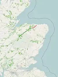 Click map to enlarge | ||||
| Route information | ||||
| Length | 62.6 mi[1] (100.7 km) | |||
| Major junctions | ||||
| Southwest end | 57°12′55″N 3°49′25″W / 57.2153°N 3.8235°W | |||
| North end | 57°38′59″N 2°38′21″W / 57.6498°N 2.6392°W | |||
| Location | ||||
| Country | United Kingdom | |||
| Primary destinations | Aviemore, Grantown-on-Spey, Banff | |||
| Road network | ||||
| ||||
The A95 road is a major road of north-east Scotland connecting the A9 road in the Highlands to the A98 road near the coast.
Route
It leaves the A9 four miles north of Aviemore.
It then goes:
- through Drumullie;
- near to Dulnain Bridge – junction with A938 road;
- through Craggan
- near to Grantown-on-Spey – junctions with A939 road;
- through Cromdale
- through Mains of Dalvey;
- over the Bridge of Avon;
- through Aberlour;
- through Craigellachie – junctions with A941 road;
- through Maggieknockater, Mulben, Tauchers and Rosarie;
- joins the A96 road west of Keith leaving it east of that town;
- through Farmtown, Drumnagarroch, Glenbarry, Gordonstown and Cornhill
It ends with a junction with the A98 road between Portsoy and Banff.
References
Wikimedia Commons has media related to A95 road (Scotland).
- ↑ "Driving directions to A95". Google Maps. Retrieved 22 September 2013.
A roads in Zone 9 of the Great Britain road numbering scheme | ||
|---|---|---|
57°28′05″N 3°13′48″W / 57.468°N 3.230°W
This article is issued from Wikipedia. The text is licensed under Creative Commons - Attribution - Sharealike. Additional terms may apply for the media files.