35°05′00″N 63°03′00″E / 35.0833°N 63.050°E
Ab Kamari | |
|---|---|
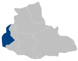 Ab Kamari District within Badghis Province | |
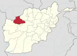
| Country | Afghanistan |
| Province | Badghis |
| Area | |
| • Land | 1,817 km2 (702 sq mi) |
| Population | |
| • Estimate (2002) | 36,300 |
Ab Kamari is a district in the west of Badghis Province, Afghanistan. Its population was estimated at 36,300 in 2002, the ethnic makeup of which was approximately 80% Tajik with a Pashtun minority. The district capital is Sang Atesh. Other localities include Ab Khuda'i, Alkhan, Anjir, Duzdanak, Gana Gul, Khalifa, and Papal. Ab Kamari is known for its pistachio forests.[1][2]
References
- ↑ "UNHCR District Profile" (PDF). Afghanistan Information Management Service. 2002-08-26. Archived from the original (PDF) on 2005-10-27. Retrieved 2006-05-03.
- ↑ "Ab Kamari District".
External links
- Map of Ab Kamari (PDF)
This article is issued from Wikipedia. The text is licensed under Creative Commons - Attribution - Sharealike. Additional terms may apply for the media files.