Andahuaylas
Anta Waylla | |
|---|---|
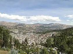 Panoramic view of the Andahuaylas district | |
| Country | |
| Region | Apurímac |
| Province | Andahuaylas |
| Capital | Andahuaylas |
| Government | |
| • Mayor | Victor Manuel Molina Quintana |
| Area | |
| • Total | 370.03 km2 (142.87 sq mi) |
| Elevation | 2,926 m (9,600 ft) |
| Population | |
| • Total | 34,087 |
| • Density | 92/km2 (240/sq mi) |
| Time zone | UTC-5 (PET) |
| UBIGEO | 030201 |
| Website | muniandahuaylas.gob.pe |
Andahuaylas District is one of the nineteen districts of the Andahuaylas Province in Peru.[1]
Geography
One of the highest peaks of the district is Saqra Urqu at approximately 4,400 m (14,400 ft). Other mountains are listed below:[2]
- Anta Qaqa
- Atuq Wachanan
- Chaku Urqu
- Ch'iqu Rumi
- Kampanayuq
- Kunturillu
- Liq'i Yakana Pampa
- Parya Qaqa
- Pukar
- Puywan
- Saqsa Waman
- Supay P'ukru
- Wanqani
- Yana Urqu
- Yura Qaqa
Ethnic groups
The people in the district are mainly indigenous citizens of Quechua descent. Quechua is the language which the majority of the population (52.01%) learnt to speak in childhood, 47.49% of the residents started speaking using the Spanish language (2007 Peru Census).[3]
See also
References
- ↑ (in Spanish) Instituto Nacional de Estadística e Informática. Banco de Información Digital Archived April 23, 2008, at the Wayback Machine. Retrieved April 4, 2008.
- ↑ escale.minedu.gob.pe/ UGEL map Andahuaylas Province (Apurímac Region)
- ↑ inei.gob.pe Archived January 27, 2013, at the Wayback Machine INEI, Peru, Censos Nacionales 2007, Frequencias: Preguntas de Población
13°39′27″S 73°23′00″W / 13.65750°S 73.38333°W
This article is issued from Wikipedia. The text is licensed under Creative Commons - Attribution - Sharealike. Additional terms may apply for the media files.