Ano Panta
Πάνω Πάντα | |
|---|---|
Region of Othoni island | |
 Settlement of Chorio, Ano Panta, Othoni island, Greece | |
| Location | Othonoi, Diapontia Islands, Greece |
| Settlements | |
| Demonym | Panopantitis (Greek: Πανωπαντίτης) |
| Time zone | UTC+2 (Eastern European Time) |
| • Summer (DST) | UTC+3 (Eastern European Summer Time) |
| ISO 3166 code | GRE |
Ano Panta (Greek: Άνω Πάντα) is one of the two regions of Othoni island, near Corfu, Greece. It includes the western villages of the island (Chorio, Dafni, Stavros etc.) while Kato Panta (Greek: Κάτω Πάντα) covers the central and eastern part of Othoni.[1]: 37 [2]
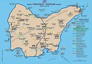
Othonoi map showings the geographical boundaries between Ano Panta and Kato Panta
| Settlement | Region |
|---|---|
| Chorio | Ano Panta |
| Dafni (including Fragoplatika, Nikolatika and Mogiatika) | Ano Panta |
| Stavros | Ano Panta |
| Vitsentziatika | Ano Panta |
| Argyratika | Ano Panta |
| Deletatika | Kato Panta |
| Damaskatika | Ano Panta |
| Katsouratika | Kato Panta |
| Ammos | Kato Panta |
| Papadatika | Kato Panta |
| Mastoratika | Kato Panta |
| Kasimatika | Kato Panta |
| Benardatika | Kato Panta |
| Pagalatika | Kato Panta |
| Katsouratika | Kato Panta |
| Mihatika | Kato Panta |
| Avlakia | Kato Panta |
References
- ↑ Ιόνιον άκρων, εκδόσεις. ΈΨΙΛΟΝ. 2000. ISBN 960-7062-99-X.
- ↑ "Οθωνοί: Το νησί της Καλυψούς είναι το δυτικότερο σημείο της Ελλάδας (Photos + Video)". 6 December 2017.
This article is issued from Wikipedia. The text is licensed under Creative Commons - Attribution - Sharealike. Additional terms may apply for the media files.