| Arctomys Peak | |
|---|---|
 Arctomys Peak summit cairn, the Lyells in back | |
| Highest point | |
| Elevation | 2,793 m (9,163 ft)[1] |
| Prominence | 184 m (604 ft)[2] |
| Listing | Mountains of Alberta |
| Coordinates | 51°56′20″N 117°00′18″W / 51.939°N 117.005°W[3] |
| Geography | |
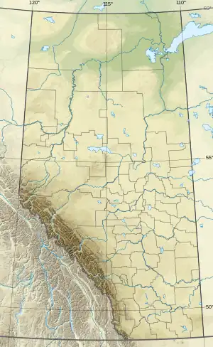 Arctomys Peak Location in Alberta  Arctomys Peak Arctomys Peak (Canada) | |
| Country | Canada |
| Provinces | Alberta |
| Topo map | NTS 82N10 Blaeberry River[3] |
| Climbing | |
| First ascent | 1918 by the Interprovincial Boundary Commission[2] |
| Easiest route | Via Glacier Lake trail (as for the Lyells). |
Arctomys Peak is a summit in Alberta, Canada.[4]
Arctomys Peak was given the scientific name by Arthur O. Wheeler of a type of marmot native to the region.[5]
References
- ↑ "Arctomys Peak". cdnrockiesdatabases.ca. Retrieved 2019-11-08.
- 1 2 "Arctomys Peak". Bivouac.com. Retrieved 2019-11-08.
- 1 2 "Arctomys Peak (AB)". Geographical Names Data Base. Natural Resources Canada. Retrieved 2019-11-08.
- ↑ "Arctomys Peak". Geographical Names Data Base. Natural Resources Canada.
- ↑ Place-names of Alberta. Ottawa: Geographic Board of Canada. 1928. p. 12.
This article is issued from Wikipedia. The text is licensed under Creative Commons - Attribution - Sharealike. Additional terms may apply for the media files.