Armaillé | |
|---|---|
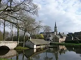 A general view of Armaillé | |
Location of Armaillé | |
 Armaillé  Armaillé | |
| Coordinates: 47°42′54″N 1°07′39″W / 47.715°N 1.1275°W | |
| Country | France |
| Region | Pays de la Loire |
| Department | Maine-et-Loire |
| Arrondissement | Segré |
| Canton | Segré-en-Anjou Bleu |
| Intercommunality | Anjou Bleu Communauté |
| Government | |
| • Mayor (2020–2026) | Emmanuelle Galisson[1] |
| Area 1 | 16.78 km2 (6.48 sq mi) |
| Population | 317 |
| • Density | 19/km2 (49/sq mi) |
| Time zone | UTC+01:00 (CET) |
| • Summer (DST) | UTC+02:00 (CEST) |
| INSEE/Postal code | 49010 /49420 |
| Elevation | 39–100 m (128–328 ft) (avg. 97 m or 318 ft) |
| 1 French Land Register data, which excludes lakes, ponds, glaciers > 1 km2 (0.386 sq mi or 247 acres) and river estuaries. | |
Armaillé (French pronunciation: [aʁmaje]) is a commune in the Maine-et-Loire department in western France.
Geography
The village lies on the right bank of the Verzée, which flows east-southeast through the commune.
Population
| Year | Pop. | ±% p.a. |
|---|---|---|
| 1968 | 403 | — |
| 1975 | 335 | −2.61% |
| 1982 | 307 | −1.24% |
| 1990 | 297 | −0.41% |
| 1999 | 290 | −0.26% |
| 2007 | 294 | +0.17% |
| 2012 | 293 | −0.07% |
| 2017 | 314 | +1.39% |
| Source: INSEE[3] | ||
See also
References
- ↑ "Répertoire national des élus: les maires" (in French). data.gouv.fr, Plateforme ouverte des données publiques françaises. 13 September 2022.
- ↑ "Populations légales 2021". The National Institute of Statistics and Economic Studies. 28 December 2023.
- ↑ Population en historique depuis 1968, INSEE
Wikimedia Commons has media related to Armaillé.
This article is issued from Wikipedia. The text is licensed under Creative Commons - Attribution - Sharealike. Additional terms may apply for the media files.