| Arrow Peak | |
|---|---|
 | |
| Highest point | |
| Elevation | 12,962 ft (3,951 m)[1] |
| Prominence | 1,313 ft (400 m)[2] |
| Parent peak | Mount Pinchot |
| Isolation | 4.6 mi (7.4 km)[2] |
| Listing | SPS Mountaineers Peak |
| Coordinates | 36°55′43″N 118°29′27″W / 36.92861°N 118.49083°W[1] |
| Geography | |
 Arrow Peak | |
| Country | United States of America |
| State | California |
| County | Fresno |
| Parent range | Sierra Nevada |
| Climbing | |
| First ascent | Bolton Brown (1895)[3] |
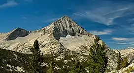
Arrow Peak is a 12,962-foot (3,951 m)[1] summit of the Sierra Nevada in Fresno County, California, located within Kings Canyon National Park.[2] Arrow Peak is situated at the north end of the Muro Blanco (also known as Arrow Ridge), a chain of high cliffs along the South Fork Kings River.[3]
See also
References
- 1 2 3 U.S. Geological Survey Geographic Names Information System: Arrow Peak (California)
- 1 2 3 "Arrow Peak". Peakbagger. Retrieved 6 July 2017.
- 1 2 "Arrow Peak". Summitpost. 2 Oct 2013. Retrieved 6 July 2017.
This article is issued from Wikipedia. The text is licensed under Creative Commons - Attribution - Sharealike. Additional terms may apply for the media files.