| Arrowsmith Range | |
|---|---|
 | |
| Highest point | |
| Peak | Mount Arrowsmith |
| Elevation | 2,781 m (9,124 ft) |
| Coordinates | 43°21′25.5″S 170°58′38″E / 43.357083°S 170.97722°E |
| Dimensions | |
| Length | 10 km (6.2 mi) |
| Geography | |
| Country | New Zealand |
| Region | Canterbury region |
| District | Ashburton District |
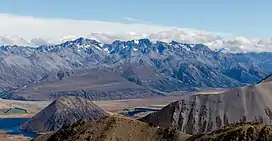
The Arrowsmith Range is a mountain range in the South Island of New Zealand. The range runs from southwest to northeast, parallel to the main ranges of the Southern Alps / Kā Tiritiri o te Moana. At the northeastern end, the range terminates at Jagged Peak (2,706 metres (8,878 ft)), whence a ridge connects to the Jollie Range. The lower Potts Range is a continuation at the southwestern end of the range. The highest point on the range is Mount Arrowsmith (2,781 metres (9,124 ft)).[1]
It is believed that the range was named in honour of John Arrowsmith, the 19th century British cartographer.[2]
Peaks
Named peaks from northwest to southeast[1]
| Name | Elevation (m) |
|---|---|
| Prop Peak | 2408 |
| Jagged Peak | 2706 |
| Upham Peak | 2705 |
| Tower Peak | 2690 |
| The Twins | 2564 |
| Couloir Peak | 2642 |
| Mount Arrowsmith | 2781 |
| Ashburton Peak | 2359 |
| Hakatere Peak | 2298 |
| South Peak | 2343 |
Rivers
The northwest side of the range is drained by the Lawrence River, a tributary of the Rangitata River, and the southeast side by the Ashburton River South Branch / Hakatere and the Cameron River which flows to Lake Heron.
Glaciers
Although the peaks do not have permanent ice or snow, there are a number of permanent snowfields and glaciers on the range:
- Jagged Glacier
- Douglas Glacier
- Cameron Glacier
- South Cameron Glacier
- Ashburton Glacier
References
- 1 2 New Zealand 1:50000 Topographic Map Series sheet BX18 – Whitcombe Pass
- ↑ Wises New Zealand Guide, 7th Edition 1979 p 13