| Awakino River | |
|---|---|
 The Awakino is the Wairoa tributary, which joins it from the north, nearest to the mouth | |
| Location | |
| Country | New Zealand |
| Physical characteristics | |
| Source | |
| • location | Tutāmoe Range |
| • elevation | 770 m (2,530 ft) |
| Mouth | |
• location | Dargaville |
• elevation | 0m |
| Length | 38 km (24 mi) |
| Basin size | 116 km2 (45 sq mi)[1] |
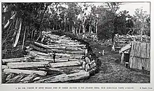
Awakino River blocked by logs in 1914
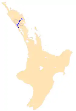
The Awakino River is a river of the Kaipara District in Northland Region. It flows 38 km (24 mi),[2] generally south from the Awakino Stream, which rises on the Tutāmoe Range, to reach the Wairoa River on the eastern edge of Dargaville.[3] The river is crossed by SH14[4] and the mothballed Dargaville Branch railway.[5]
The New Zealand Ministry for Culture and Heritage gives a translation of "Bad creek",[6] which accords with a 1981 description of "a slow, meandering drain through willows, swamp and flax lands, with little interest" and lined with muddy stop banks.[2]
See also
References
"Place name detail: Waikawau River". New Zealand Gazetteer. New Zealand Geographic Board. Retrieved 12 July 2009.
- ↑ Rivers and streams, Northland Regional Council
- 1 2 "Recreational River Survey" (PDF). NIWA. 1981. Archived (PDF) from the original on 17 April 2021.
- ↑ "Awakino River, Northland". NZ Topo Map. Retrieved 4 December 2021.
- ↑ "State Hwy 14". Google Maps. June 2019. Archived from the original on 4 December 2021. Retrieved 4 December 2021.
- ↑ "Dargaville Rails To Be Linked In Six Weeks. NORTHERN ADVOCATE". paperspast.natlib.govt.nz. 30 January 1940. Archived from the original on 4 December 2021. Retrieved 4 December 2021.
- ↑ "1000 Māori place names". New Zealand Ministry for Culture and Heritage. 6 August 2019.
This article is issued from Wikipedia. The text is licensed under Creative Commons - Attribution - Sharealike. Additional terms may apply for the media files.