Ban Maet
บ้านแมด | |
|---|---|
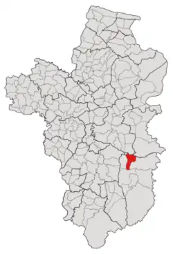 Subdistrict location in Ubon Ratchathani province | |
| Country | Thailand |
| Province | Ubon Ratchathani |
| District | Buntharik |
| Number of Muban | 12 |
| Number of Mu | 12 |
| Subdistrict established | 1987 |
| Area | |
| • Total | 96 km2 (37 sq mi) |
| Population (2021) | |
| • Total | 8,542 |
| • Density | 88.98/km2 (230.5/sq mi) |
| Time zone | UTC+7 (ICT) |
| Postal code | 34230 |
Ban Maet (Thai: บ้านแมด) is a tambon (subdistrict) located in the northwestern region of Buntharik district, in Ubon Ratchathani Province, Thailand.[1][2][3] In 2021, it had a population of 8,542 people.[1] Neighbouring subdistricts are (clockwise from the south) Nong Sano, Na Pho, Non Kalong, Non Ko, and Kho Laen.[4]
History
Previously, Ban Maet was a small village located on the left bank of Huay Dod Creek (ห้วยโดด), one of the tributaries of the Lam Dom Noi River, and was governed by Kho Laen.[2] Later in 1973, it was separated from Kho Laen to form a new subdivision, Na Pho, with seven other villages.[2][5]
Due to deforestation, the steam levels of the four water creeks in the area, including Huay Dod, Huay Thalaeng, Huay Thaen, and Huay Kham, were drastically decreased. As a result, people began to conquer the formerly flooded land and establish more communities,[2] including the Ban Maet village, which increased in population and eventually gained subdistrict status in 1987 by absorbing six other settlements in the Na Pho subdistrict's eastern half.[2][3]
After its establishment, tambon (subdistrict) Ban Maet was governed by the subdistrict council, which was later promoted to the Subdistrict Administrative Organization (SAO) in 1996.[2]
Geography
The tambon covers 96 km2 and is located in the northwestern region of the Buntharik district, on the Lam Dom Noi river basins.[4]
Administration
The subdistrict of Ban Maet is divided into 12 villages (mubans; หมู่บ้าน).[1][4] As of the 2021 census, it had a population of 8,542 people with 2,479 households.[1]
Since 1996, the Subdistrict Administrative Organization of Ban Maet (องค์การบริหารส่วนตำบลบ้านแมด; Ban Maet SAO) has been the local government responding to administer the area.[1][2][4]
The following is a list of the subdistrict's mubans, which roughly correspond to the villages.[1]
| Village | Group (Mu) | Household | Population | |
|---|---|---|---|---|
| Romanized name | Thai name | |||
| Hat Sai Khun | หาดทรายคูณ | 1 | 168 | 377 |
| Bok Charoen | บกเจริญ | 2 | 168 | 612 |
| Na Khaen | นาแคน | 3 | 312 | 1,003 |
| Maet | แมด | 4 | 276 | 938 |
| Non Sombun | โนนสมบูรณ์ | 5 | 279 | 941 |
| Nong Kham Yai | หนองขามใหญ่ | 6 | 138 | 471 |
| Non Kalong Noi | โนนกาหลงน้อย | 7 | 97 | 330 |
| Hat Tai | หาดใต้ | 8 | 252 | 923 |
| Hat Mai Pattana | หาดใหม่พัฒนา | 9 | 263 | 938 |
| Na Khaen Pattana | นาแคนพัฒนา | 10 | 267 | 732 |
| Hat Nuea | หาดเหนือ | 11 | 139 | 595 |
| Don Chod | ดอนโจด | 12 | 120 | 709 |
| Central House Registration | 0 | 0 | ||
| Total | 2,479 | 8,542 | ||
References
- 1 2 3 4 5 6 "โครงสร้างข้อมูลสถิติจำนวนประชากร" (in Thai). Department of Provincial Administration of Thailand. 2021. Archived from the original on 14 December 2022. Retrieved 15 December 2022. Alt URL
- 1 2 3 4 5 6 7 "ประวัติความเป็นมา". www.banmaed.go.th (in Thai). Subdistrict Administrative Organization of Ban Maet. Archived from the original on 14 August 2022. Retrieved 17 December 2022.
- 1 2 "ประกาศกระทรวงมหาดไทย เรื่อง ตั้งและเปลี่ยนแปลงเขตตำบลในท้องที่อำเภอตระการพืชผลบุณฑริก ศรีเมืองใหม่และอำเภออำนาจเจริญ จังหวัดอุบลราชธานี" (PDF). www.ratchakitcha.soc.go.th (in Thai). Royal Thai Government Gazette. 31 July 1987. Archived from the original (PDF) on 5 June 2022. Retrieved 17 December 2022.
- 1 2 3 4 "สภาพทั่วไป". www.banmaed.go.th (in Thai). Subdistrict Administrative Organization of Ban Maet. Archived from the original on 18 June 2022. Retrieved 18 December 2022.
- ↑ "ประกาศกระทรวงมหาดไทย เรื่อง ตั้งและเปลี่นแปลงเขตตำบลในท้องที่อำเภออำนาจเจริญ อำเภอบุณฑริก และอำเภอพนา จังหวัดอุบลราชธานี" (PDF). www.ratchakitcha.soc.go.th (in Thai). Royal Thai Government Gazette. 4 September 1973. Archived from the original (PDF) on 5 June 2022. Retrieved 17 December 2022.