Banyard, Arkansas | |
|---|---|
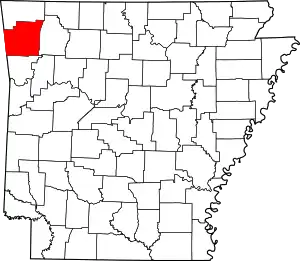
 Banyard, Arkansas Banyard's position in Arkansas. | |
| Coordinates: 35°45′36″N 94°12′25″W / 35.76000°N 94.20694°W | |
| Country | |
| State | |
| County | Washington |
| Township | Winslow |
| Elevation | 604 m (1,982 ft) |
| Time zone | UTC-6 (Central (CST)) |
| • Summer (DST) | UTC-5 (CDT) |
| ZIP code | 72701 |
| Area code | 479 |
| GNIS feature ID | 72959 |
| U.S. Geological Survey Geographic Names Information System: Banyard, Arkansas | |
Banyard is an unincorporated community in Winslow Township, Washington County, Arkansas, United States.[2] It is located on Bunyard Road near the Crawford County line west of the Bobby Hopper Tunnel.[3]
References
- ↑ "Banyard, Arkansas". Histopolis. Retrieved August 3, 2011.
- ↑ U.S. Geological Survey Geographic Names Information System: Banyard, Arkansas United States Geological Survey. Retrieved 3 August 2011.
- ↑ Arkansas Atlas and Gazetteer (Map) (Second ed.). DeLorme. § 22.
This article is issued from Wikipedia. The text is licensed under Creative Commons - Attribution - Sharealike. Additional terms may apply for the media files.