Ben Arous Governorate
ولاية بن عروس | |
|---|---|
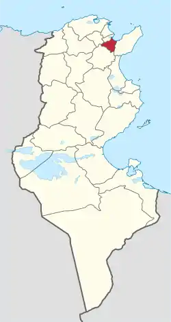 Map of Tunisia with Ben Arous highlighted | |
| Coordinates: 36°44′50″N 10°20′0″E / 36.74722°N 10.33333°E | |
| Country | |
| Created | 3 December 1983[1] |
| Capital | Ben Arous |
| Government | |
| • Governor | Ezzedine Chalbi (since 2021) |
| Area | |
| • Total | 761 km2 (294 sq mi) |
| • Rank | Ranked 22nd of 24 |
| Population (2019) | |
| • Total | 712,172 |
| • Rank | Ranked 6th of 24 |
| • Density | 940/km2 (2,400/sq mi) |
| Time zone | UTC+01 (CET) |
| Postal prefix | xx |
| ISO 3166 code | TN-13 |
Ben Arous Governorate (Tunisian Arabic: ولاية بن عروس Wilāyat Bin ‘Arūs pronounced [bɪn.ʕæˈruːs]; French: Gouvernorat de Ben Arous) is one of the twenty-four governorates of Tunisia. It is in the north-east of Tunisia and adjoins smaller Tunis Governorate. It covers an area of 761 km²[1] and had a population of 712,172 as at the 2019 census.[2][3] The capital is Ben Arous.
Geography
The governorate is centred 10 kilometres (6.2 mi) from the capital and surrounded by the governorates of Tunis, Zaghouan, Manouba, and Nabeul. It has a short coastline, along the Gulf of Tunis to the northeast including the country's main commercial port, Radès.[1]
The average temperature is between 6.8 °C and 17.9 °C, and annual rainfall is 275–515 millimeters.[1]
Economy
Agriculture
| Land use | |
|---|---|
| Agricultural land | 370 km² (47% of total land) |
| Woodland | 160 km² |
| Transportation | 40 km² |
| Uncultivated | 201 km² |
| Livestock | |
| Cattle | 5 200 |
| Sheep | 28 000 |
| Goats | 4 000 |
| Main produce (in metric tons per year) | |
| Peaches | 27 000 |
| Apples and pairs | 21 500 |
| Grapes | 41 500 |
| Durum wheat, soft wheat and other types | 2 420 |
| Red meat | 1 700 |
| White meat | 18 300 |
| Milk | 13 500 |
| Eggs | 167 million (total) |
| Abattoirs | 4 (registered under Directive Plan of 2010) |
| Hydrological resources | |
| River weirs/dams | 1 (Oued El Hma) |
| Upland lakes | 24 |
| Upland weirs/dams | 3 |
| Main produce for export | |
| Flowers | c. 12 million per year |
| Clams and shellfish landed | 61 tonnes |
Administrative divisions
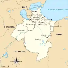
Administratively, the governorate is divided into twelve delegations (mutamadiyat), eleven municipalities, six rural councils, and 75 sectors (imadas).[1] The delegations and their populations from the 2004 and 2014 censuses,[2] are listed below:
| Delegation | Population in 2004 | Population in 2014 |
|---|---|---|
| Ben Arous | 32,329 | 31,128 |
| Bou Mhel El Bassatine | 27,977 | 40,101 |
| El Mourouj | 81,986 | 104,538 |
| Ezzahra | 31,792 | 34,962 |
| Fouchana | 56,628 | 74,868 |
| Hammam Chôtt | 24,847 | 31,858 |
| Hammam Lif | 38,401 | 42,518 |
| La Nouvelle Medina | 42,603 | 57,194 |
| Megrine | 24,031 | 26,720 |
| Mohamedia | 46,613 | 66,439 |
| Mornag | 53,709 | 61,518 |
| Radès | 44,857 | 59,998 |
Eleven municipalities are in Ben Arous Governorate:
| Code | Municipality | Population (2014)[4] |
|---|---|---|
| 1311 | Ben Arous | 88,322 |
| 1312 | El Mourouj | 104,586 |
| 1313 | Hammam Lif | 42,518 |
| 1314 | Hammam Chott | 31,810 |
| 1315 | Bou Mhel el-Bassatine | 40,101 |
| 1316 | Ezzahra | 34,962 |
| 1317 | Radès | 59,794 |
| 1318 | Mégrine | 26,924 |
| 1319 | Mohamedia-Fouchana | 106,167 |
| 1320 | Mornag | 30,058 |
| 1321 | Khalidia | 8,470 |
References
- 1 2 3 4 5 6 (in French) "tunisieindustrie.nat.tn".
- 1 2 "2014 Tunisian census data". Archived from the original on 2015-05-18.
- ↑ (in French) Census 2014 (National Institute of Statistics) Archived 2014-10-29 at the Wayback Machine
- ↑ Recensement Général de la Population et de l'Habitat 2014 – Population, logements et ménages par commune et arrondissement [Census 2014 results – population, accommodation and households per municipality and delegation] (Report) (in French). National Institute of Statistics. 1 April 2015. Retrieved 18 February 2016.
Governorates and regions of Tunisia | ||
|---|---|---|
| Governorates | ||
| Regions | ||
WikiProject Tunisia | ||