Benson, Louisiana | |
|---|---|
 Benson, Louisiana  Benson, Louisiana | |
| Coordinates: 31°51′59″N 93°41′38″W / 31.86639°N 93.69389°W | |
| Country | United States |
| State | Louisiana |
| Parish | DeSoto |
| Elevation | 256 ft (78 m) |
| Time zone | UTC-6 (Central (CST)) |
| • Summer (DST) | UTC-5 (CDT) |
| Area code | 318 |
| GNIS feature ID | 542982[1] |
Benson is an unincorporated community in DeSoto Parish, Louisiana, United States.[1][2]
Located approximately halfway between Mansfield and Converse on the Kansas City Southern Railroad, it is an historic sawmill town.[3]
Notes
Municipalities and communities of DeSoto Parish, Louisiana, United States | ||
|---|---|---|
| City | 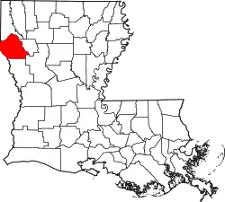 | |
| Towns | ||
| Villages | ||
| CDPs | ||
| Other unincorporated communities | ||
This article is issued from Wikipedia. The text is licensed under Creative Commons - Attribution - Sharealike. Additional terms may apply for the media files.