Berghaupten | |
|---|---|
 Coat of arms | |
Location of Berghaupten within Ortenaukreis district 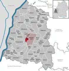 | |
 Berghaupten 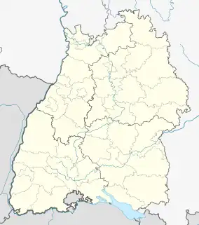 Berghaupten | |
| Coordinates: 48°24′25″N 07°59′13″E / 48.40694°N 7.98694°E | |
| Country | Germany |
| State | Baden-Württemberg |
| Admin. region | Freiburg |
| District | Ortenaukreis |
| Government | |
| • Mayor (2017–25) | Philipp Clever[1] |
| Area | |
| • Total | 9.69 km2 (3.74 sq mi) |
| Elevation | 172 m (564 ft) |
| Population (2021-12-31)[2] | |
| • Total | 2,437 |
| • Density | 250/km2 (650/sq mi) |
| Time zone | UTC+01:00 (CET) |
| • Summer (DST) | UTC+02:00 (CEST) |
| Postal codes | 77791 |
| Dialling codes | 07803 |
| Vehicle registration | OG, BH, KEL, LR, WOL |
| Website | www.berghaupten.de |
Berghaupten (Low Alemannic: Berghoupte) is a municipality in the district of Ortenau in Baden-Württemberg in Germany. Furthermore, it is a state-approved resort located in the Black Forest. Neighbouring municipalities are Ohlsbach (in the north), Gengenbach (in the east), Hohberg (in the south – west) as well as Offenburg (in the north-west).
On the nearby hill of Geißkopf (359 m) there is evidence of a Roman or Germanic military encampment.
References
- ↑ Aktuelle Wahlergebnisse, Staatsanzeiger, accessed 13 September 2021.
- ↑ "Bevölkerung nach Nationalität und Geschlecht am 31. Dezember 2021" [Population by nationality and sex as of December 31, 2021] (CSV) (in German). Statistisches Landesamt Baden-Württemberg. June 2022.
This article is issued from Wikipedia. The text is licensed under Creative Commons - Attribution - Sharealike. Additional terms may apply for the media files.